IMAGES TAKEN NEAR TO
North Farm Road, TUNBRIDGE WELLS, TN2 3XD
Introduction
This page details the photographs taken nearby to North Farm Road, TN2 3XD by members of the Geograph project.
The Geograph project started in 2005 with the aim of publishing, organising and preserving representative images for every square kilometre of Great Britain, Ireland and the Isle of Man.

There are currently over 7.5m images from over14,400 individuals and you can help contribute to the project by visiting https://www.geograph.org.uk
Image Map
Images are licensed for reuse under creativecommons.org/licenses/by-sa/2.0
Notes
- Clicking on the map will re-center to the selected point.
- The higher the marker number, the further away the image location is from the centre of the postcode.
Image Listing (1343 Images Found)
Images are licensed for reuse under creativecommons.org/licenses/by-sa/2.0
Image
Details
Distance
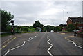
1
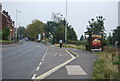
Bus Stop, Upper Grosvenor Rd
Bus Stop for High Brooms Station
Image: © N Chadwick
Taken: 19 Sep 2009
0.01 miles
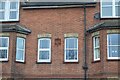
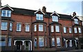
2
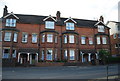
Victorian houses opposite High Brooms Station
These houses have the markings of The High Brooms Brick and Tile Company (HBBC).
Image: © N Chadwick
Taken: 30 Aug 2010
0.01 miles
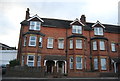
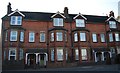
4
Large Victorian terraced houses, North Farm Rd
The (former) High Brooms Brick and Tile Company logo can be seen on these buildings.
Image: © N Chadwick
Taken: 3 May 2010
0.01 miles
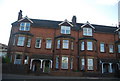
10
Victorian Terraced houses outside High Brooms Station
Built by the old High Brooms Borough Council, no longer in existence.
Image: © N Chadwick
Taken: 19 Feb 2009
0.02 miles