IMAGES TAKEN NEAR TO
Harries Road, TUNBRIDGE WELLS, TN2 3TW
Introduction
This page details the photographs taken nearby to Harries Road, TN2 3TW by members of the Geograph project.
The Geograph project started in 2005 with the aim of publishing, organising and preserving representative images for every square kilometre of Great Britain, Ireland and the Isle of Man.

There are currently over 7.5m images from over14,400 individuals and you can help contribute to the project by visiting https://www.geograph.org.uk
Image Map
Images are licensed for reuse under creativecommons.org/licenses/by-sa/2.0
Notes
- Clicking on the map will re-center to the selected point.
- The higher the marker number, the further away the image location is from the centre of the postcode.
Image Listing (205 Images Found)
Images are licensed for reuse under creativecommons.org/licenses/by-sa/2.0
Image
Details
Distance
6
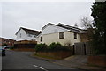
Brethren's Meeting Room. Milton Drive, Liptraps Lane
This converted house, registered for marriages in 1995, can hold 120 worshippers. By 2004 its capacity was being unsustainably exceeded, so its trustees sought planning permission to open a larger meeting hall in nearby Five Oak Green. The Sherwood building was retained for some services, though.
Image: © N Chadwick
Taken: 28 Feb 2009
0.07 miles