IMAGES TAKEN NEAR TO
Sherwood Road, TUNBRIDGE WELLS, TN2 3LH
Introduction
This page details the photographs taken nearby to Sherwood Road, TN2 3LH by members of the Geograph project.
The Geograph project started in 2005 with the aim of publishing, organising and preserving representative images for every square kilometre of Great Britain, Ireland and the Isle of Man.

There are currently over 7.5m images from over14,400 individuals and you can help contribute to the project by visiting https://www.geograph.org.uk
Image Map
Images are licensed for reuse under creativecommons.org/licenses/by-sa/2.0
Notes
- Clicking on the map will re-center to the selected point.
- The higher the marker number, the further away the image location is from the centre of the postcode.
Image Listing (215 Images Found)
Images are licensed for reuse under creativecommons.org/licenses/by-sa/2.0
Image
Details
Distance
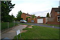
1
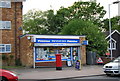
Sherwood Store, Sherwood Rd
A former post office now just a general stores.
Image: © N Chadwick
Taken: 10 May 2009
0.02 miles

7
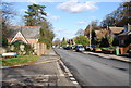
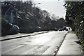
Sandhurst Rd (3)
Residential road in northern Tunbridge Wells
Image: © N Chadwick
Taken: 22 Nov 2008
0.06 miles


10
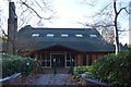
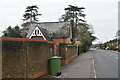
Church of Jesus Christ Latter Day Saints
Image: © N Chadwick
Taken: 18 Nov 2018
0.07 miles