IMAGES TAKEN NEAR TO
Kingsnorth Road, ASHFORD, TN23 6LY
Introduction
This page details the photographs taken nearby to Kingsnorth Road, TN23 6LY by members of the Geograph project.
The Geograph project started in 2005 with the aim of publishing, organising and preserving representative images for every square kilometre of Great Britain, Ireland and the Isle of Man.

There are currently over 7.5m images from over14,400 individuals and you can help contribute to the project by visiting https://www.geograph.org.uk
Image Map
Images are licensed for reuse under creativecommons.org/licenses/by-sa/2.0
Notes
- Clicking on the map will re-center to the selected point.
- The higher the marker number, the further away the image location is from the centre of the postcode.
Image Listing (24 Images Found)
Images are licensed for reuse under creativecommons.org/licenses/by-sa/2.0
Image
Details
Distance
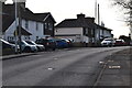
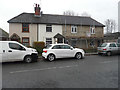
2
Building site for eight houses, The Limes
Planning permission has been granted by Ashford Borough Council under application number 14/00093/AS for the “removal of existing play equipment and provision of 8 self-contained dwellings (C3 use class), ancillary single storey unit and associated parking and access”. The site used to be a playground.
Image: © John Baker
Taken: 25 Jan 2015
0.06 miles
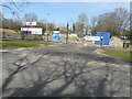
3
Looking northeast across Kingsnorth Road
Towards where the Image is ongoing.
Image: © John Baker
Taken: 21 Dec 2016
0.06 miles
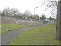
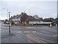
4
Recently completed houses, The Limes
Compared with Image, this development for vulnerable young people, aged 18-25, appears to have been completed but the locked gate seems to indicate that the buildings are still unoccupied.
Image: © John Baker
Taken: 21 Dec 2016
0.06 miles
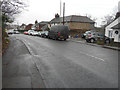
5
Renovation of 256, Kingsnorth Road
The external render has been removed and new windows and doors have been installed.
Image: © John Baker
Taken: 21 Dec 2016
0.07 miles
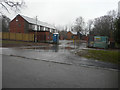
6
Building site for eight houses, The Limes
Compared with Image but seen from another angle, little progress appears to have been made to the construction of the houses. Planning permission has been granted by Ashford Borough Council under application number 14/00093/AS for the “removal of existing play equipment and provision of 8 self-contained dwellings (C3 use class), ancillary single storey unit and associated parking and access”. The site used to be a playground.
Image: © John Baker
Taken: 12 Apr 2015
0.07 miles
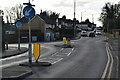
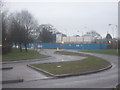
7
Roundabout on Kingsnorth Road
Kingsnorth Road heads straight on towards Beaver Lane from Kingsnorth. Wotton Road heads right towards a 'B and Q' Warehouse and then the A2042 Romney Marsh Road
Image: © David Anstiss
Taken: 21 Feb 2010
0.07 miles
10
Stanhope Road development site
This run down estate is being re-developed in phases. This site is being developed by Moat Housing. One of the founder members of the successful Chrysalis Consortium (managing the estate) on this major housing PFI (Private Finance Initiative) estate in Ashford, Kent. The consortium consists of Denne Construction, Gleeson Homes, Moat Housing, Nationwide and Powerminster.
Image: © David Anstiss
Taken: 21 Feb 2010
0.12 miles