IMAGES TAKEN NEAR TO
Tennyson Road, ASHFORD, TN23 6LR
Introduction
This page details the photographs taken nearby to Tennyson Road, TN23 6LR by members of the Geograph project.
The Geograph project started in 2005 with the aim of publishing, organising and preserving representative images for every square kilometre of Great Britain, Ireland and the Isle of Man.

There are currently over 7.5m images from over14,400 individuals and you can help contribute to the project by visiting https://www.geograph.org.uk
Image Map
Images are licensed for reuse under creativecommons.org/licenses/by-sa/2.0
Notes
- Clicking on the map will re-center to the selected point.
- The higher the marker number, the further away the image location is from the centre of the postcode.
Image Listing (22 Images Found)
Images are licensed for reuse under creativecommons.org/licenses/by-sa/2.0
Image
Details
Distance
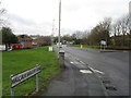
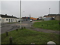
7
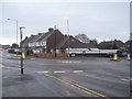
Roundabout on Kingsnorth Road
Kingsnorth Road heads straight on towards Beaver Lane from Kingsnorth. Wotton Road heads right towards a 'B and Q' Warehouse and then the A2042 Romney Marsh Road
Image: © David Anstiss
Taken: 21 Feb 2010
0.12 miles
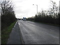
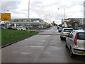
8
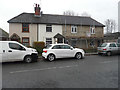
Renovation of 256, Kingsnorth Road
The external render has been removed and new windows and doors have been installed.
Image: © John Baker
Taken: 21 Dec 2016
0.13 miles