IMAGES TAKEN NEAR TO
Hedgerows, ASHFORD, TN23 5WL
Introduction
This page details the photographs taken nearby to Hedgerows, TN23 5WL by members of the Geograph project.
The Geograph project started in 2005 with the aim of publishing, organising and preserving representative images for every square kilometre of Great Britain, Ireland and the Isle of Man.

There are currently over 7.5m images from over14,400 individuals and you can help contribute to the project by visiting https://www.geograph.org.uk
Image Map
Images are licensed for reuse under creativecommons.org/licenses/by-sa/2.0
Notes
- Clicking on the map will re-center to the selected point.
- The higher the marker number, the further away the image location is from the centre of the postcode.
Image Listing (3 Images Found)
Images are licensed for reuse under creativecommons.org/licenses/by-sa/2.0
Image
Details
Distance
1
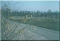
Singleton Hill in 1975
Houses have since been built on the fields beyond the fence so hiding any view of Ashford nowadays. In this view one can discern the gas holder (now demolished) near to Gasworks Lane.
Image: © John Baker
Taken: Unknown
0.20 miles
2
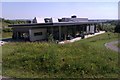
Singleton Environment Centre, Ashford, TN23 5LW
There are meeting rooms for hire, and a public cafe here. The building is operated by The Conservation Volunteers which describes itself as the UK's leading practical conservation charity. Here is a link to the Singleton Environment Centre website http://www.tcv.org.uk/singleton
Image: © Danny P Robinson
Taken: 25 Jul 2012
0.21 miles
3
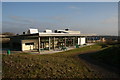
Singleton Environment Centre
BTCV in Kent. Footprints cafe. See http://www2.btcv.org.uk/display/about for more details about British Trust for Conservation Volunteers (BTCV) and http://www.ourfootprint.co.uk for the Footprints cafe.
Image: © Angus Willson
Taken: 11 Dec 2008
0.25 miles