IMAGES TAKEN NEAR TO
Flaxpond Road, ASHFORD, TN23 5PP
Introduction
This page details the photographs taken nearby to Flaxpond Road, TN23 5PP by members of the Geograph project.
The Geograph project started in 2005 with the aim of publishing, organising and preserving representative images for every square kilometre of Great Britain, Ireland and the Isle of Man.

There are currently over 7.5m images from over14,400 individuals and you can help contribute to the project by visiting https://www.geograph.org.uk
Image Map
Images are licensed for reuse under creativecommons.org/licenses/by-sa/2.0
Notes
- Clicking on the map will re-center to the selected point.
- The higher the marker number, the further away the image location is from the centre of the postcode.
Image Listing (22 Images Found)
Images are licensed for reuse under creativecommons.org/licenses/by-sa/2.0
Image
Details
Distance
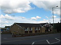
1
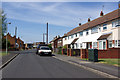
May Pits, Ashford
Housing probably originally council houses - they always have the upper windows right up against the eaves.
Image: © Robin Webster
Taken: 21 Apr 2007
0.04 miles
2
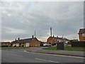
Brookfield Road at the junction of Allen Field
Image: © David Howard
Taken: 10 Apr 2016
0.11 miles
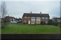
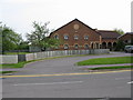
4
Baptist Chapel on Brookfield Road
Image: © Oast House Archive
Taken: 21 Mar 2010
0.11 miles
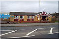
5
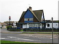
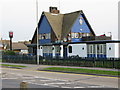
Front view of The Crusader pub on Brookfield Road
Image: © Nick Smith
Taken: 23 Apr 2009
0.12 miles
8
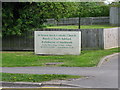
Sign for the Catholic church, Brookfield Road
Image: © Nick Smith
Taken: 23 Apr 2009
0.13 miles
9
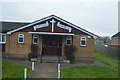
South Ashford Baptist Church
On B229 Brookfield Road.
Image: © David Anstiss
Taken: 28 Apr 2009
0.13 miles
10
The St Simon Stock Catholic church, Brookfield Road
Image: © Nick Smith
Taken: 23 Apr 2009
0.13 miles