IMAGES TAKEN NEAR TO
Woodside, ASHFORD, TN23 5LQ
Introduction
This page details the photographs taken nearby to Woodside, TN23 5LQ by members of the Geograph project.
The Geograph project started in 2005 with the aim of publishing, organising and preserving representative images for every square kilometre of Great Britain, Ireland and the Isle of Man.

There are currently over 7.5m images from over14,400 individuals and you can help contribute to the project by visiting https://www.geograph.org.uk
Image Map
Images are licensed for reuse under creativecommons.org/licenses/by-sa/2.0
Notes
- Clicking on the map will re-center to the selected point.
- The higher the marker number, the further away the image location is from the centre of the postcode.
Image Listing (4 Images Found)
Images are licensed for reuse under creativecommons.org/licenses/by-sa/2.0
Image
Details
Distance
1
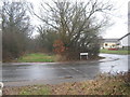
Lost byway in Stanhope
Due to the construction of the Stanhope Estate in the 60's a byway leading to Cuckoo Lane from Chart Road,has been left to overgrow and return to nature.
Image: © David Anstiss
Taken: 21 Feb 2010
0.21 miles
4
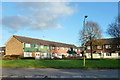
Houses off Stanhope Road, Ashford
Road access is from behind via Frittenden Close.
Image: © Robin Webster
Taken: 4 Dec 2015
0.24 miles