IMAGES TAKEN NEAR TO
Hever Gardens, ASHFORD, TN23 5GN
Introduction
This page details the photographs taken nearby to Hever Gardens, TN23 5GN by members of the Geograph project.
The Geograph project started in 2005 with the aim of publishing, organising and preserving representative images for every square kilometre of Great Britain, Ireland and the Isle of Man.

There are currently over 7.5m images from over14,400 individuals and you can help contribute to the project by visiting https://www.geograph.org.uk
Image Map
Images are licensed for reuse under creativecommons.org/licenses/by-sa/2.0
Notes
- Clicking on the map will re-center to the selected point.
- The higher the marker number, the further away the image location is from the centre of the postcode.
Image Listing (19 Images Found)
Images are licensed for reuse under creativecommons.org/licenses/by-sa/2.0
Image
Details
Distance
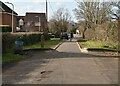
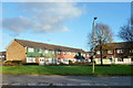
1
Stanhope Estate, Ashford
The tenement blocks shown are typical of this 1960s housing estate which was built primarily for the London overspill. Current regeneration plans (2005) involve demolition of the old flat blocks so this may soon be a scene from the past.
Image: © Adam Colton
Taken: 31 Oct 2005
0.08 miles
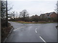
5
Byway from Chart Road
This green lane is a byway that should lead to Cuckoo Lane near Singleton. Some of it still exists but some sections are blocked and impassable. This section leads to Washford Farm Road.
Image: © David Anstiss
Taken: 21 Feb 2010
0.18 miles
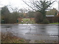
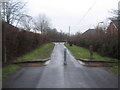
6
Road junction on Pound Lane
Pound Lane from Kingsnorth becomes Millbank Road heading towards Stanhope. On the left is Chart Road heading towards Singleton.
Image: © David Anstiss
Taken: 21 Feb 2010
0.18 miles
8
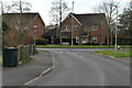
Houses off Stanhope Road, Ashford
Road access is from behind via Frittenden Close.
Image: © Robin Webster
Taken: 4 Dec 2015
0.20 miles
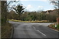
9
Footpath section of Millbank Road
Millbank Road from Pound Lane becomes a footpath then returns to roadway after a short section. This is due to Christchurch School on the northern section of Millbank Road. Road would become a dangerous 'rat run' otherwise.
Image: © David Anstiss
Taken: 21 Feb 2010
0.20 miles