IMAGES TAKEN NEAR TO
Matfield Close, ASHFORD, TN23 5EY
Introduction
This page details the photographs taken nearby to Matfield Close, TN23 5EY by members of the Geograph project.
The Geograph project started in 2005 with the aim of publishing, organising and preserving representative images for every square kilometre of Great Britain, Ireland and the Isle of Man.

There are currently over 7.5m images from over14,400 individuals and you can help contribute to the project by visiting https://www.geograph.org.uk
Image Map
Images are licensed for reuse under creativecommons.org/licenses/by-sa/2.0
Notes
- Clicking on the map will re-center to the selected point.
- The higher the marker number, the further away the image location is from the centre of the postcode.
Image Listing (20 Images Found)
Images are licensed for reuse under creativecommons.org/licenses/by-sa/2.0
Image
Details
Distance
1
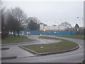
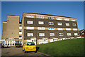
Stanhope Road development site
This run down estate is being re-developed in phases. This site is being developed by Moat Housing. One of the founder members of the successful Chrysalis Consortium (managing the estate) on this major housing PFI (Private Finance Initiative) estate in Ashford, Kent. The consortium consists of Denne Construction, Gleeson Homes, Moat Housing, Nationwide and Powerminster.
Image: © David Anstiss
Taken: 21 Feb 2010
0.04 miles
2
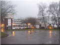
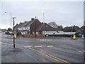
Ray Allen Sure Start Centre, Stanhope
This multi-function place is on 1 Stanhope Road.
It has a community cafe 'Lightbites', children's centre, Adult Education Centre, Healthy Living Centre and hall for hire.
See http://www.direct.gov.uk/en/Parents/Preschooldevelopmentandlearning/NurseriesPlaygroupsReceptionClasses/DG_173054 for more details on Sure Start.
See http://www.ashford.gov.uk/AshfordGov1.1/about_the_borough/local_services/venues_for_hire/ray_allen_centre.aspx for more details on the hall.
Image: © David Anstiss
Taken: 21 Feb 2010
0.09 miles
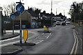
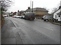
7
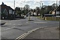
Roundabout on Kingsnorth Road
Kingsnorth Road heads straight on towards Beaver Lane from Kingsnorth. Wotton Road heads right towards a 'B and Q' Warehouse and then the A2042 Romney Marsh Road
Image: © David Anstiss
Taken: 21 Feb 2010
0.12 miles
9
Looking northeast across Kingsnorth Road
Towards where the Image is ongoing.
Image: © John Baker
Taken: 21 Dec 2016
0.16 miles
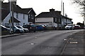
10
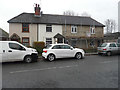
Renovation of 256, Kingsnorth Road
The external render has been removed and new windows and doors have been installed.
Image: © John Baker
Taken: 21 Dec 2016
0.16 miles