IMAGES TAKEN NEAR TO
Hoxton Close, ASHFORD, TN23 5EP
Introduction
This page details the photographs taken nearby to Hoxton Close, TN23 5EP by members of the Geograph project.
The Geograph project started in 2005 with the aim of publishing, organising and preserving representative images for every square kilometre of Great Britain, Ireland and the Isle of Man.

There are currently over 7.5m images from over14,400 individuals and you can help contribute to the project by visiting https://www.geograph.org.uk
Image Map
Images are licensed for reuse under creativecommons.org/licenses/by-sa/2.0
Notes
- Clicking on the map will re-center to the selected point.
- The higher the marker number, the further away the image location is from the centre of the postcode.
Image Listing (16 Images Found)
Images are licensed for reuse under creativecommons.org/licenses/by-sa/2.0
Image
Details
Distance
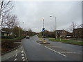
1
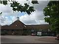
The Singleton Centre
Small shopping centre on Hoxton Close.
Image: © David Anstiss
Taken: 7 Aug 2010
0.00 miles
2

Singleton Barn Pub Sign
Sign for Image
In the car park on Hoxton Close.
Image: © David Anstiss
Taken: 7 Aug 2010
0.03 miles
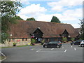
3
The Singleton Barn, Ashford (2)
Another view of Image
Image: © David Anstiss
Taken: 7 Aug 2010
0.04 miles
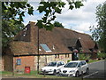
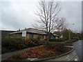
4
The Singleton Barn, Ashford
Converted Barn of Singleton Manor, now a Public House and Restaurant on Hoxton Close.
Image: © David Anstiss
Taken: 7 Aug 2010
0.05 miles
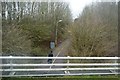
7
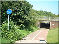
Subway under the A28, Great Chart
A vital link for pedestrians and cyclists between Great Chart and Ashford
Image: © Oliver Dixon
Taken: 17 Jun 2002
0.13 miles
8
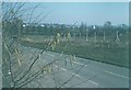
Singleton Hill in 1975
Houses have since been built on the fields beyond the fence so hiding any view of Ashford nowadays. In this view one can discern the gas holder (now demolished) near to Gasworks Lane.
Image: © John Baker
Taken: Unknown
0.17 miles
9
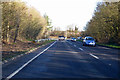
A28 towards Canterbury
Bypassing Great Chart to the left and most of Ashford to the right.
Image: © Robin Webster
Taken: 17 Jan 2019
0.18 miles