IMAGES TAKEN NEAR TO
Hillbrow Lane, ASHFORD, TN23 4XJ
Introduction
This page details the photographs taken nearby to Hillbrow Lane, TN23 4XJ by members of the Geograph project.
The Geograph project started in 2005 with the aim of publishing, organising and preserving representative images for every square kilometre of Great Britain, Ireland and the Isle of Man.

There are currently over 7.5m images from over14,400 individuals and you can help contribute to the project by visiting https://www.geograph.org.uk
Image Map
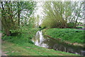
Images are licensed for reuse under creativecommons.org/licenses/by-sa/2.0
Notes
- Clicking on the map will re-center to the selected point.
- The higher the marker number, the further away the image location is from the centre of the postcode.
Image Listing (47 Images Found)
Images are licensed for reuse under creativecommons.org/licenses/by-sa/2.0
Image
Details
Distance
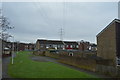
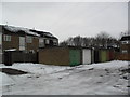
2
Oaklands
1970s houses in Ashford.
Image: © Burgess Von Thunen
Taken: 8 Feb 2012
0.07 miles
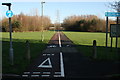
5
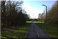
Path across Watercress Field to Ford Way
Image: © Robert Eva
Taken: 30 Nov 2018
0.11 miles
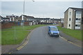
6
Brookfield Road at the junction of Knoll Lane
Image: © David Howard
Taken: 10 Apr 2016
0.11 miles
7
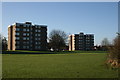
Bailey's Fields flats
View across what is known locally as Watercress Fields
Image: © Angus Willson
Taken: 7 Dec 2008
0.13 miles
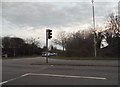
8
Victoria Park
also known as Watercress Fields close to Ford Way. Also has football pitches.
Image: © Angus Willson
Taken: 7 Dec 2008
0.13 miles