IMAGES TAKEN NEAR TO
Great Chart Bypass, ASHFORD, TN23 4RR
Introduction
This page details the photographs taken nearby to Great Chart Bypass, TN23 4RR by members of the Geograph project.
The Geograph project started in 2005 with the aim of publishing, organising and preserving representative images for every square kilometre of Great Britain, Ireland and the Isle of Man.

There are currently over 7.5m images from over14,400 individuals and you can help contribute to the project by visiting https://www.geograph.org.uk
Image Map
Images are licensed for reuse under creativecommons.org/licenses/by-sa/2.0
Notes
- Clicking on the map will re-center to the selected point.
- The higher the marker number, the further away the image location is from the centre of the postcode.
Image Listing (90 Images Found)
Images are licensed for reuse under creativecommons.org/licenses/by-sa/2.0
Image
Details
Distance
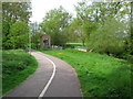
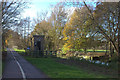
3
View along the Stour Valley Walk
In the direction of Buxford Mill.
Image: © Nick Smith
Taken: 23 Apr 2009
0.07 miles
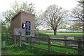
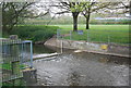
6
Water gauging station by the Great Stour
Image: © Robert Eva
Taken: 30 Nov 2018
0.08 miles
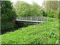
7
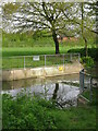
Small weir on the Great Stour near Singleton Lake
Image: © Nick Smith
Taken: 23 Apr 2009
0.08 miles
9
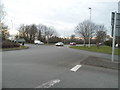
Roundabout on Brookfield Road, Ashford
Image: © David Howard
Taken: 10 Apr 2016
0.09 miles
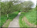
10
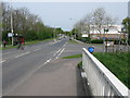
Junction of Leacon Road with Brookfield Road
Image: © Nick Smith
Taken: 23 Apr 2009
0.10 miles