IMAGES TAKEN NEAR TO
Leacon Road, ASHFORD, TN23 4AJ
Introduction
This page details the photographs taken nearby to Leacon Road, TN23 4AJ by members of the Geograph project.
The Geograph project started in 2005 with the aim of publishing, organising and preserving representative images for every square kilometre of Great Britain, Ireland and the Isle of Man.

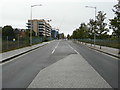
There are currently over 7.5m images from over14,400 individuals and you can help contribute to the project by visiting https://www.geograph.org.uk
Image Map
Images are licensed for reuse under creativecommons.org/licenses/by-sa/2.0
Notes
- Clicking on the map will re-center to the selected point.
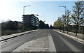
- The higher the marker number, the further away the image location is from the centre of the postcode.
Image Listing (124 Images Found)
Images are licensed for reuse under creativecommons.org/licenses/by-sa/2.0
Image
Details
Distance
1
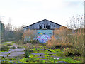
Derelict premises, Ashford
This was once mapped as a tractor repair depot.
Image: © Robin Webster
Taken: 4 Dec 2015
0.02 miles
2
Derelict buildings beside Leacon Road
Before Leacon Road was joined with Victoria Road, the pavement to the left of the road sign would have been part of Gasworks Lane, which can be seen beyond the traffic lights in Image
Image: © John Baker
Taken: 9 May 2013
0.02 miles
3
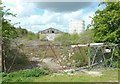
Derelict building and gasholder
Seen from the now pedestrianised section of Gasworks Lane.
Image: © John Baker
Taken: 9 May 2013
0.02 miles
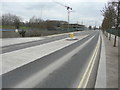
4
Leacon Road
With one of the Image and a gasholder on the right. I am curious to know what will become of the waste ground behind the wire fence.
Image: © John Baker
Taken: 9 May 2013
0.03 miles
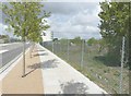
5
Victoria Road
The large apartment blocks, some of which are still under construction, stand in Leacon Road and have been given the name Riverside Park https://greassets.co.uk/projects/riverside-park
The view of Image shows the traffic island I was standing on to take this view.
Image: © John Baker
Taken: 14 Oct 2019
0.03 miles
6
Victoria Road
The large apartment blocks, some of which are still under construction, stand in Leacon Road and have been given the name Riverside Park https://greassets.co.uk/projects/riverside-park
This photo of Image was taken from the same location in October 2019.
Image: © John Baker
Taken: 23 Mar 2020
0.03 miles
7
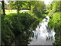
The Great Stour near Victoria Park
As seen from a footbridge to Gasworks Lane from the Park. The path on the right is part of the Stour Valley Walk (long distance path) leading to Great Chart from Ashford.
Image: © David Anstiss
Taken: 28 Apr 2009
0.04 miles
8
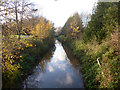
Great Stour, Ashford, looking upstream
Victoria Park is on the left.
Image: © Robin Webster
Taken: 4 Dec 2015
0.04 miles
9
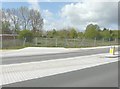
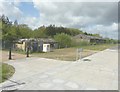
Waste land beside Leacon Road
It is possible that the site will be used for industrial buildings sometime in the future.
Image: © John Baker
Taken: 9 May 2013
0.05 miles
10
Victoria Road
The large apartment block, under construction, stands in Leacon Road and has been given the name Riverside Park https://greassets.co.uk/projects/riverside-park
This is a similar view of Image but taken further away from the development in July 2018.
Image: © John Baker
Taken: 1 Apr 2018
0.05 miles