IMAGES TAKEN NEAR TO
Dover Place, ASHFORD, TN23 1HU
Introduction
This page details the photographs taken nearby to Dover Place, TN23 1HU by members of the Geograph project.
The Geograph project started in 2005 with the aim of publishing, organising and preserving representative images for every square kilometre of Great Britain, Ireland and the Isle of Man.

There are currently over 7.5m images from over14,400 individuals and you can help contribute to the project by visiting https://www.geograph.org.uk
Image Map
Images are licensed for reuse under creativecommons.org/licenses/by-sa/2.0
Notes
- Clicking on the map will re-center to the selected point.
- The higher the marker number, the further away the image location is from the centre of the postcode.
Image Listing (314 Images Found)
Images are licensed for reuse under creativecommons.org/licenses/by-sa/2.0
Image
Details
Distance
3
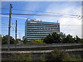
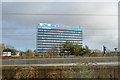
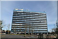
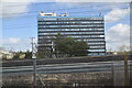
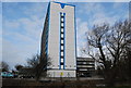
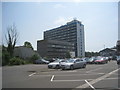
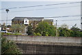
International House, Ashford
Seen from platform 6 of Ashford International railway station. The overhead wires of the high speed line to the Channel Tunnel (which bypasses the station) can be seen in the foreground.
Image: © Richard Vince
Taken: 29 Jul 2017
0.01 miles
4
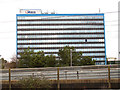
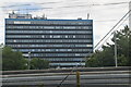
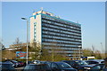
International House, Ashford
A large office block, which appears from online searches to have been occupied at various times by DEFRA and Natural England. I'm not sure who occupies it now.
Image: © Stephen Craven
Taken: 12 Apr 2013
0.01 miles