IMAGES TAKEN NEAR TO
Carlton Road, ASHFORD, TN23 1DP
Introduction
This page details the photographs taken nearby to Carlton Road, TN23 1DP by members of the Geograph project.
The Geograph project started in 2005 with the aim of publishing, organising and preserving representative images for every square kilometre of Great Britain, Ireland and the Isle of Man.

There are currently over 7.5m images from over14,400 individuals and you can help contribute to the project by visiting https://www.geograph.org.uk
Image Map
Images are licensed for reuse under creativecommons.org/licenses/by-sa/2.0
Notes
- Clicking on the map will re-center to the selected point.
- The higher the marker number, the further away the image location is from the centre of the postcode.
Image Listing (53 Images Found)
Images are licensed for reuse under creativecommons.org/licenses/by-sa/2.0
Image
Details
Distance
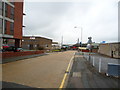
2
Railway access ramp and west end trackwork, Ashford
The line splitting to either side of the ramp gives connections from Network Rail to platforms at the station shared with stopping Channel Tunnel trains. The main Channel Tunnel lines bypassing the station, together with connections to the shared platforms, are here in tunnel beneath this surface layout.
Image: © Robin Webster
Taken: 4 Dec 2015
0.09 miles
4
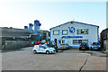
Hire centre, Bridge Road, Ashford
At the end of what turned out to be a dead-end on this industrial estate, even for pedestrians.
Image: © Robin Webster
Taken: 4 Dec 2015
0.09 miles
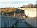
7
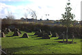
Park with pyramids, Sackville Crescent
A tiny patch of green with concrete blocks looking like redundant triangulation points.
I have now found out that these are WW2 tank traps called Dragons' Teeth. Thanks to John Baker for that information.
Image: © Robert Eva
Taken: 30 Nov 2018
0.11 miles
9
Medway Power Transmission Ltd
One of the largest business facilities on the Cobbs Wood Industrial Estate in Ashford, Kent. This 55,000 sq/ft site was derelict until 2002, when Medway Power Transmission Ltd purchased & renovated the site into a modern administration, manufacturing and distribution facility. The MEDWAY® brand ident, featured on the building, has become a symbol branded on the products manufactured or distributed from here. These products include Rod Ends, Spherical Bearings, Ball Joints & Clevises, also Vee & Wedge Belts & Pulleys, Poly Vee Belts & Pulleys, Timing Belts & Pulleys, Roller Chain & Sprockets, Flexible & Rigid Couplings, Weld On & Bolt On Hubs, Taper Bushes & Adaptors.
Image: © Mark Codner
Taken: 12 Oct 2008
0.13 miles
10
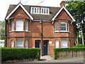
Jubilee House
On King's Avenue, close to the disused Ashford Hospital. Has an etched stone near front door on right, which reads 'Jubilee House. This house was given to the Hospital by the town of Ashford. King George's Jubilee May 1935.'
Image: © David Anstiss
Taken: 3 May 2009
0.13 miles