IMAGES TAKEN NEAR TO
Sandy Lane, UCKFIELD, TN22 5PX
Introduction
This page details the photographs taken nearby to Sandy Lane, TN22 5PX by members of the Geograph project.
The Geograph project started in 2005 with the aim of publishing, organising and preserving representative images for every square kilometre of Great Britain, Ireland and the Isle of Man.

There are currently over 7.5m images from over14,400 individuals and you can help contribute to the project by visiting https://www.geograph.org.uk
Image Map
Images are licensed for reuse under creativecommons.org/licenses/by-sa/2.0
Notes
- Clicking on the map will re-center to the selected point.
- The higher the marker number, the further away the image location is from the centre of the postcode.
Image Listing (12 Images Found)
Images are licensed for reuse under creativecommons.org/licenses/by-sa/2.0
Image
Details
Distance
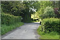
2
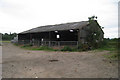
Barn off Sandy Lane
Opposite Bretts Cottages.
Image: © Oast House Archive
Taken: 25 Jul 2010
0.05 miles
5
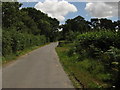
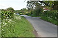
Sandy Lane at the north end of Framfield
Image: © Dave Spicer
Taken: 16 Jul 2010
0.12 miles
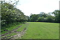
8
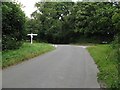
Crossroads of Etchingwood Lane and Sandy Lane
Image: © Dave Spicer
Taken: 16 Jul 2010
0.19 miles
9
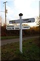
Old Direction Sign - Signpost by Sandy Lane, Framfield Parish
Black iron cap finial - 3 arms; East Sussex wood by the UC road, in parish of Framfield (Wealden District), crossroads where Sandy Lane crosses Etchingham Lane, on verge at crossroads.
Surveyed
Milestone Society National ID: SX_TQ4921.
Image: © Milestone Society
Taken: Unknown
0.20 miles