IMAGES TAKEN NEAR TO
Lewes Road, UCKFIELD, TN22 5LG
Introduction
This page details the photographs taken nearby to Lewes Road, TN22 5LG by members of the Geograph project.
The Geograph project started in 2005 with the aim of publishing, organising and preserving representative images for every square kilometre of Great Britain, Ireland and the Isle of Man.

There are currently over 7.5m images from over14,400 individuals and you can help contribute to the project by visiting https://www.geograph.org.uk
Image Map (Loading...)


Getting Data...Please wait
Leaflet Map data © OpenStreetMap
Images are licensed for reuse under creativecommons.org/licenses/by-sa/2.0
Notes
- Clicking on the map will re-center to the selected point.
- The higher the marker number, the further away the image location is from the centre of the postcode.
Image Listing (76 Images Found)
Images are licensed for reuse under creativecommons.org/licenses/by-sa/2.0
Image
Details
Distance
3
Sign for Blackboys Inn
Dating back to AD 1389 it's seen a few landlords.
Image: © Dave Spicer
Taken: 3 May 2010
0.04 miles
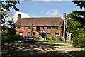
6
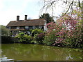
Blackboys Inn, Blackboys
The Blackboys Inn on a lovely spring afternoon.
Image: © Julia MG
Taken: 26 Apr 2008
0.06 miles
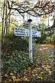
9
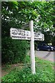
Old Direction Sign - Signpost by the B2192, Framfield parish
Black iron cap finial - 3 arms; East Sussex wood by the UC road, in Framfield parish (Wealden District), on the west side of the T junction of the B2192 and Hollow Lane.
Surveyed
Milestone Society National ID: SX_TQ5220B
Image: © K Sharp
Taken: 16 Jun 2015
0.06 miles