IMAGES TAKEN NEAR TO
Lewes Road, UCKFIELD, TN22 5JH
Introduction
This page details the photographs taken nearby to Lewes Road, TN22 5JH by members of the Geograph project.
The Geograph project started in 2005 with the aim of publishing, organising and preserving representative images for every square kilometre of Great Britain, Ireland and the Isle of Man.

There are currently over 7.5m images from over14,400 individuals and you can help contribute to the project by visiting https://www.geograph.org.uk
Image Map (Loading...)


Getting Data...Please wait
Leaflet Map data © OpenStreetMap
Images are licensed for reuse under creativecommons.org/licenses/by-sa/2.0
Notes
- Clicking on the map will re-center to the selected point.
- The higher the marker number, the further away the image location is from the centre of the postcode.
Image Listing (17 Images Found)
Images are licensed for reuse under creativecommons.org/licenses/by-sa/2.0
Image
Details
Distance
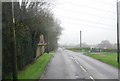
2
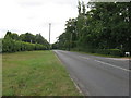
The B2192 at Eason's Green
North east towards Blackboys.
Image: © Dave Spicer
Taken: 16 Jul 2010
0.06 miles
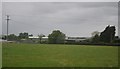
5
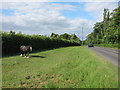
Horse by the B2192
Tethered horse near to Diamond Farm.
Image: © Oast House Archive
Taken: 20 May 2011
0.11 miles
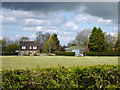
6
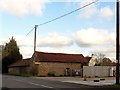
Converted farm building, Eason's Green
Image: © nick macneill
Taken: 9 Nov 2012
0.12 miles
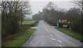
9
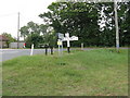
Signpost at the junction of the B2192 and Palehouse Common road
Image: © Dave Spicer
Taken: 16 Jul 2010
0.14 miles
