IMAGES TAKEN NEAR TO
Framfield Road, UCKFIELD, TN22 5HD
Introduction
This page details the photographs taken nearby to Framfield Road, TN22 5HD by members of the Geograph project.
The Geograph project started in 2005 with the aim of publishing, organising and preserving representative images for every square kilometre of Great Britain, Ireland and the Isle of Man.

There are currently over 7.5m images from over14,400 individuals and you can help contribute to the project by visiting https://www.geograph.org.uk
Image Map (Loading...)


Getting Data...Please wait
Leaflet Map data © OpenStreetMap
Images are licensed for reuse under creativecommons.org/licenses/by-sa/2.0
Notes
- Clicking on the map will re-center to the selected point.
- The higher the marker number, the further away the image location is from the centre of the postcode.
Image Listing (11 Images Found)
Images are licensed for reuse under creativecommons.org/licenses/by-sa/2.0
Image
Details
Distance
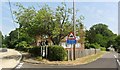
3
Pure Plants
A nursery started in 2003 that aims to present the best garden plants grown sustainably.
Image: © Jonathan Billinger
Taken: 6 Feb 2007
0.12 miles
4
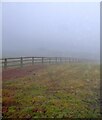
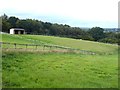
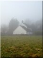
Great Blacklys
The name of the field according to Framfield's 1840 tithe map that is bounded by Framfield Road, the B2102, to the south and Tickerage Wood to the north. The latter is obscured by the thick mist that lingered until around 11am on this morning.
Image: © Simon Carey
Taken: 14 Feb 2023
0.14 miles
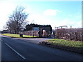
5
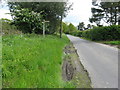
Peddlars, Stonebridge Lane
Not marked on Framfield's 1840 tithe map but does appear on the 1874 OS map.
Image: © Simon Carey
Taken: 14 Feb 2023
0.15 miles
6

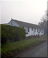
White cottages near Blackboys
The cottages could be described as 'Flemish style'.
Image: © nick macneill
Taken: 21 Jul 2013
0.15 miles
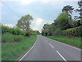
9
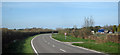
Gatehouse Lane
Road to Uckfield. Holly Grove to the right.
Image: © Oast House Archive
Taken: 10 Apr 2010
0.20 miles
10
Rathowen, Framfield Road, Blackboys
Viewed through the thick mist from the public footpath that links Framfield Road, the B2102, to Tickerage Lane.
Image: © Simon Carey
Taken: 14 Feb 2023
0.21 miles