IMAGES TAKEN NEAR TO
Shepherds Hill, UCKFIELD, TN22 5GQ
Introduction
This page details the photographs taken nearby to Shepherds Hill, TN22 5GQ by members of the Geograph project.
The Geograph project started in 2005 with the aim of publishing, organising and preserving representative images for every square kilometre of Great Britain, Ireland and the Isle of Man.

There are currently over 7.5m images from over14,400 individuals and you can help contribute to the project by visiting https://www.geograph.org.uk
Image Map
Images are licensed for reuse under creativecommons.org/licenses/by-sa/2.0
Notes
- Clicking on the map will re-center to the selected point.
- The higher the marker number, the further away the image location is from the centre of the postcode.
Image Listing (32 Images Found)
Images are licensed for reuse under creativecommons.org/licenses/by-sa/2.0
Image
Details
Distance
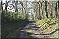
4

Leech Pit Field
The name of the field according to Buxted's 1840 tithe map that is bounded by Shepherds Hill to the south. The south west corner of the current field has been given over to an orchard.
Image: © Simon Carey
Taken: 5 Feb 2023
0.09 miles
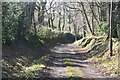
9
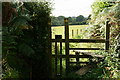
Stile on Shepherd's Hill
Located to the south-east of Buxted.
Image: © Peter Trimming
Taken: 18 Sep 2017
0.11 miles
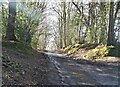
10
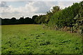
Footpath on Shepherd's Hill
Located to the south-east of Buxted, with the path keeping to the field boundary, behind the fence.
Image: © Peter Trimming
Taken: 18 Sep 2017
0.12 miles