IMAGES TAKEN NEAR TO
Maresfield By Pass, UCKFIELD, TN22 5EP
Introduction
This page details the photographs taken nearby to Maresfield By Pass, TN22 5EP by members of the Geograph project.
The Geograph project started in 2005 with the aim of publishing, organising and preserving representative images for every square kilometre of Great Britain, Ireland and the Isle of Man.

There are currently over 7.5m images from over14,400 individuals and you can help contribute to the project by visiting https://www.geograph.org.uk
Image Map (Loading...)


Getting Data...Please wait
Leaflet Map data © OpenStreetMap
Images are licensed for reuse under creativecommons.org/licenses/by-sa/2.0
Notes
- Clicking on the map will re-center to the selected point.
- The higher the marker number, the further away the image location is from the centre of the postcode.
Image Listing (14 Images Found)
Images are licensed for reuse under creativecommons.org/licenses/by-sa/2.0
Image
Details
Distance
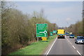
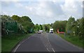
2
Black Down Roundabout
The A26 & A22 join at this roundabout.
Image: © N Chadwick
Taken: 29 Apr 2010
0.04 miles
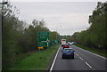
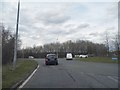
4

Field, Budlett's Common
Viewed from the car park of the Little Chef which lies next to Black Down Roundabout.
Image: © Simon Carey
Taken: 28 Jun 2009
0.06 miles
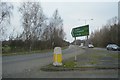
5
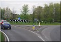
Black Down Roundabout
The A22 joins the A26.
Image: © N Chadwick
Taken: 29 Apr 2010
0.06 miles
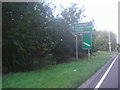
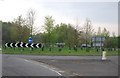
8
The A22 approaching Batts Bridge roundabout
Image: © David Howard
Taken: 12 Sep 2011
0.12 miles