IMAGES TAKEN NEAR TO
Baker Street, UCKFIELD, TN22 5BL
Introduction
This page details the photographs taken nearby to Baker Street, TN22 5BL by members of the Geograph project.
The Geograph project started in 2005 with the aim of publishing, organising and preserving representative images for every square kilometre of Great Britain, Ireland and the Isle of Man.

There are currently over 7.5m images from over14,400 individuals and you can help contribute to the project by visiting https://www.geograph.org.uk
Image Map
Images are licensed for reuse under creativecommons.org/licenses/by-sa/2.0
Notes
- Clicking on the map will re-center to the selected point.
- The higher the marker number, the further away the image location is from the centre of the postcode.
Image Listing (97 Images Found)
Images are licensed for reuse under creativecommons.org/licenses/by-sa/2.0
Image
Details
Distance
2
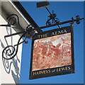
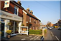
The Alma sign
Sign for Image, a Harvey's of Lewes pub on Framfield Road.
Image: © Oast House Archive
Taken: 1 Oct 2011
0.03 miles
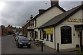
3
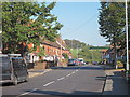
The Alma, Uckfield
A Harvey's of Lewes pub on Framfield Road.
Also see Image
Image: © Oast House Archive
Taken: 1 Oct 2011
0.03 miles
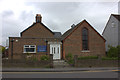
6
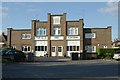
Uckfield old fire station
Uckfield old fire station, Keld Avenue, Uckfield, East Sussex, dating from 1937, now converted into dwellings
Image: © Kevin Hale
Taken: 17 Oct 2007
0.05 miles
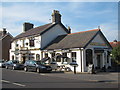
7
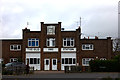
Old Fire Station, Keld Avenue
Now converted to flats
Image: © Robert Eva
Taken: 22 Apr 2017
0.05 miles
9
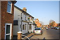
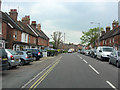
Framfield Road
Residential road leading out of Uckfield towards Framfield.
Image: © Oast House Archive
Taken: 1 Oct 2011
0.06 miles