IMAGES TAKEN NEAR TO
Rosers Common, UCKFIELD, TN22 4QA
Introduction
This page details the photographs taken nearby to Rosers Common, TN22 4QA by members of the Geograph project.
The Geograph project started in 2005 with the aim of publishing, organising and preserving representative images for every square kilometre of Great Britain, Ireland and the Isle of Man.

There are currently over 7.5m images from over14,400 individuals and you can help contribute to the project by visiting https://www.geograph.org.uk
Image Map
Images are licensed for reuse under creativecommons.org/licenses/by-sa/2.0
Notes
- Clicking on the map will re-center to the selected point.
- The higher the marker number, the further away the image location is from the centre of the postcode.
Image Listing (10 Images Found)
Images are licensed for reuse under creativecommons.org/licenses/by-sa/2.0
Image
Details
Distance
2
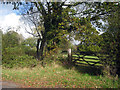
Field Gate at end of Chapel Lane
Image: © Oast House Archive
Taken: 25 Oct 2009
0.14 miles
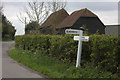
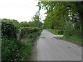
3
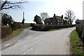
Road junction near Popeswood Farm
Rosers Common off to the left
Image: © Julian P Guffogg
Taken: 24 Mar 2012
0.14 miles
6
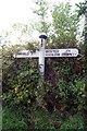
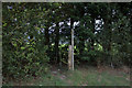
Old Direction Sign - Signpost by Pound Green Lane, Buxted parish
Black iron cap finial - 3 arms; East Sussex wood by the UC road, in parish of Buxted (Wealden District), Pound Green Lane junction with Rosers Common, on verge.
Surveyed
Milestone Society National ID: SX_TQ5123A
Image: © Milestone Society
Taken: Unknown
0.16 miles
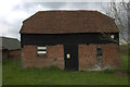
7
Pasture east of Popeswood Farm
Much ivy in the hedgerow opposite.
Image: © Jonathan Billinger
Taken: 20 Feb 2008
0.17 miles
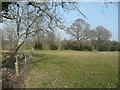
8
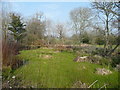
Almost dried-up pond
Opposite Popeswood Farm, east of Buxted.
Image: © Jonathan Billinger
Taken: 20 Feb 2008
0.18 miles
9
Pound Green Lane north towards the A272
Image: © Dave Spicer
Taken: 25 May 2013
0.22 miles