IMAGES TAKEN NEAR TO
Rocks Lane, UCKFIELD, TN22 4BL
Introduction
This page details the photographs taken nearby to Rocks Lane, TN22 4BL by members of the Geograph project.
The Geograph project started in 2005 with the aim of publishing, organising and preserving representative images for every square kilometre of Great Britain, Ireland and the Isle of Man.

There are currently over 7.5m images from over14,400 individuals and you can help contribute to the project by visiting https://www.geograph.org.uk
Image Map (Loading...)


Getting Data...Please wait
Leaflet Map data © OpenStreetMap
Images are licensed for reuse under creativecommons.org/licenses/by-sa/2.0
Notes
- Clicking on the map will re-center to the selected point.
- The higher the marker number, the further away the image location is from the centre of the postcode.
Image Listing (23 Images Found)
Images are licensed for reuse under creativecommons.org/licenses/by-sa/2.0
Image
Details
Distance
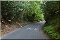
3
Rocks Lane at the junction of Hurstwood Road
Image: © David Howard
Taken: 3 Sep 2012
0.07 miles
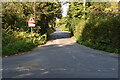
4

Rocks Lane
Going south from High Hurstwood at the Rocks Lane turning.
Image: © Nigel Freeman
Taken: 28 Sep 2005
0.08 miles
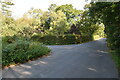
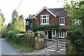
5

Direction sign and postbox near High Hurstwood
Image: © nick macneill
Taken: 21 Jul 2012
0.08 miles
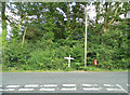
6
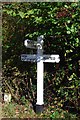
Old Direction Sign - Signpost in Buxted Parish, south of High Hurstwood
Black iron cap finial - 3 arms; East Sussex wood by the UC road, in parish of Buxted (Wealden District), junction of Rocks Lane with Hurstwood Road, on the verge.
Surveyed
Milestone Society National ID: SX_TQ4925A.
Image: © Milestone Society
Taken: Unknown
0.08 miles
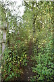
9
Bracken filled footpath near The Hermitage
Image: © Dave Spicer
Taken: 3 Jul 2010
0.12 miles