IMAGES TAKEN NEAR TO
Duddleswell, UCKFIELD, TN22 3JJ
Introduction
This page details the photographs taken nearby to TN22 3JJ by members of the Geograph project.
The Geograph project started in 2005 with the aim of publishing, organising and preserving representative images for every square kilometre of Great Britain, Ireland and the Isle of Man.

There are currently over 7.5m images from over14,400 individuals and you can help contribute to the project by visiting https://www.geograph.org.uk
Image Map (Loading...)


Getting Data...Please wait
Leaflet Map data © OpenStreetMap
Images are licensed for reuse under creativecommons.org/licenses/by-sa/2.0
Notes
- Clicking on the map will re-center to the selected point.
- The higher the marker number, the further away the image location is from the centre of the postcode.
Image Listing (30 Images Found)
Images are licensed for reuse under creativecommons.org/licenses/by-sa/2.0
Image
Details
Distance
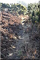
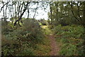
1
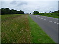
Track, Ashdown Forest
Running parallel to New Road south of Doves Nest.
Image: © Simon Carey
Taken: 22 Aug 2020
0.07 miles
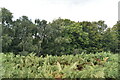
2
Entrance to Crest Farm, Ashdown Forest
Ashdown Forest is a former medieval hunting forest, and is the highest ridge of the High Weald. At ten square miles it is the largest open access area in the South East. Ashdown Forest was purchased by East Sussex County Council from the De La Warr family in 1988. It is now managed by a Board of Conservators. This view is of the sign for Crest Farm next to New Road.
Image: © Marathon
Taken: 2 Jul 2012
0.10 miles
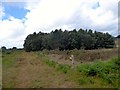
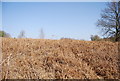
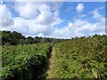
3
New Road, Ashdown Forest
Ashdown Forest is a former medieval hunting forest, and is the highest ridge of the High Weald. At ten square miles it is the largest open access area in the South East. Ashdown Forest was purchased by East Sussex County Council from the De La Warr family in 1988. It is now managed by a Board of Conservators. This view is of New Road on its way to the junction near Camp Hill.
Image: © Marathon
Taken: 2 Jul 2012
0.16 miles
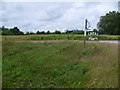
5
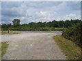
Gorsey Down car park looking north
In the distance you can make out an aerial.This area used to be full of aerials and transmitters. A reminder of the WWII.
Image: © Nigel Freeman
Taken: 6 Aug 2006
0.16 miles
6
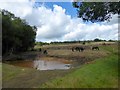
Pond, Ashdown Forest
With grazing Exmoor ponies. Areas of heathland are temporarily fenced off to allow for ponies, cattle and sheep to graze the land and thus prevent the heathland turning into birch scrub land.
Image: © Simon Carey
Taken: 22 Aug 2020
0.16 miles
8
Maresfield 82A Public Footpath, Ashdown Forest
Linking Crest Farm to the B2026.
Image: © Simon Carey
Taken: 22 Aug 2020
0.17 miles