IMAGES TAKEN NEAR TO
Markland Way, UCKFIELD, TN22 2DG
Introduction
This page details the photographs taken nearby to Markland Way, TN22 2DG by members of the Geograph project.
The Geograph project started in 2005 with the aim of publishing, organising and preserving representative images for every square kilometre of Great Britain, Ireland and the Isle of Man.

There are currently over 7.5m images from over14,400 individuals and you can help contribute to the project by visiting https://www.geograph.org.uk
Image Map (Loading...)


Getting Data...Please wait
Leaflet Map data © OpenStreetMap
Images are licensed for reuse under creativecommons.org/licenses/by-sa/2.0
Notes
- Clicking on the map will re-center to the selected point.
- The higher the marker number, the further away the image location is from the centre of the postcode.
Image Listing (55 Images Found)
Images are licensed for reuse under creativecommons.org/licenses/by-sa/2.0
Image
Details
Distance
1

Houses and bollards, Lashbrooks Road, Rocks Park
Image: © Patrick Roper
Taken: 24 Sep 2007
0.06 miles
2
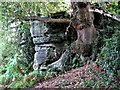
Natural sandstone outcrop, West Park Nature Reserve
The rocks along this section of the reserve are the site of a 9000 year old Mesolithic settlement
Image: © Patrick Roper
Taken: 24 Sep 2007
0.16 miles
3
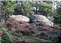
Sandrocks and heather, West Park Nature Reserve, Uckfield
Natural sandstone outcrops south of Rocks Road
Image: © Patrick Roper
Taken: 24 Sep 2007
0.17 miles
4
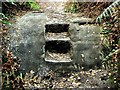
Rock cut steps in West Park Local Nature Reserve
The sandstone boulder is a natural feature in this extensive area of rock exposure.
Image: © Patrick Roper
Taken: 24 Sep 2007
0.18 miles
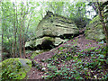
9
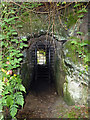
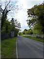
Foot tunnel under Rocks Road
Now gated and locked, this was a way between the grounds of a house called The Rocks (now called Buckswood Grange) lying to each side of the road. The near side grounds are now the Woodland Trust's Lake Wood.
Image: © Robin Webster
Taken: 1 Jun 2018
0.19 miles
10
Ardingly Sandstone outcrop, Lake Wood
There are many sandstone outcrops in this Woodland Trust property.
Image: © Robin Webster
Taken: 1 Jun 2018
0.20 miles