IMAGES TAKEN NEAR TO
Rocks Park Road, UCKFIELD, TN22 2AX
Introduction
This page details the photographs taken nearby to Rocks Park Road, TN22 2AX by members of the Geograph project.
The Geograph project started in 2005 with the aim of publishing, organising and preserving representative images for every square kilometre of Great Britain, Ireland and the Isle of Man.

There are currently over 7.5m images from over14,400 individuals and you can help contribute to the project by visiting https://www.geograph.org.uk
Image Map
Images are licensed for reuse under creativecommons.org/licenses/by-sa/2.0
Notes
- Clicking on the map will re-center to the selected point.
- The higher the marker number, the further away the image location is from the centre of the postcode.
Image Listing (31 Images Found)
Images are licensed for reuse under creativecommons.org/licenses/by-sa/2.0
Image
Details
Distance
2
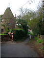
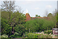
The Oast House, Belmont Road
Converted oast house once part of Bell Farm now swallowed up by the growing town of Uckfield. The path leads to the B2102.
Image: © Simon Carey
Taken: 31 Mar 2007
0.15 miles
4
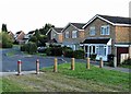
Houses and bollards, Lashbrooks Road, Rocks Park
Image: © Patrick Roper
Taken: 24 Sep 2007
0.16 miles
6
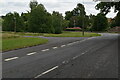
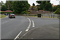
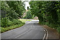
Shrubs by the B2102
On the road to Lewes near to Uckfield Fire Station
Image: © Paul Gillett
Taken: 16 Oct 2010
0.18 miles
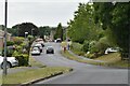
8
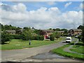
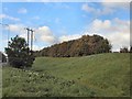
Hunters Way, Uckfield
Hunters Way is a residential road on the outskirts of Uckfield, in East Sussex.
Image: © Malc McDonald
Taken: 29 Aug 2022
0.19 miles