IMAGES TAKEN NEAR TO
London Road, UCKFIELD, TN22 1PB
Introduction
This page details the photographs taken nearby to London Road, TN22 1PB by members of the Geograph project.
The Geograph project started in 2005 with the aim of publishing, organising and preserving representative images for every square kilometre of Great Britain, Ireland and the Isle of Man.

There are currently over 7.5m images from over14,400 individuals and you can help contribute to the project by visiting https://www.geograph.org.uk
Image Map
Images are licensed for reuse under creativecommons.org/licenses/by-sa/2.0
Notes
- Clicking on the map will re-center to the selected point.
- The higher the marker number, the further away the image location is from the centre of the postcode.
Image Listing (19 Images Found)
Images are licensed for reuse under creativecommons.org/licenses/by-sa/2.0
Image
Details
Distance
1
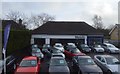
Bluauto
See also Image for an earlier version of this building.
Image: © N Chadwick
Taken: 23 Jan 2016
0.07 miles
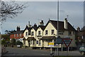
3
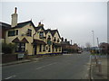
Ringles Cross public house
Ringles Cross is now a suburb of Uckfield.
Image: © Dave Spicer
Taken: 2 Sep 2012
0.09 miles
4
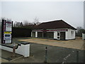
Former car dealership, Ringles Cross, Uckfield
Image: © Stacey Harris
Taken: 2 Mar 2012
0.09 miles
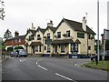
5
Ringles Cross public house, Ringles Cross, Uckfield
Image: © Stacey Harris
Taken: 2 Mar 2012
0.09 miles
6
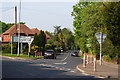
Road Junction at Ringles Cross, Sussex
The junction of London Road with Coopers Green Road.
Image: © Peter Trimming
Taken: 26 Apr 2011
0.10 miles
7
Old Milepost by the B2026, London Road, Uckfield
Metal plate detached from post by the B2026 (was A22), in parish of UCKFIELD (WEALDEN District), Ringles Cross PH, London Road, in pavement by entrance to car park, on West side of road. Bow Bells iron plate, erected by the Malling Street to Wych Cross turnpike trust in the 19th century.
Inscription reads:-
42
{Bow & 4 Bells}
East Sussex HER.
HER Ref: MES21808 https://www.heritagegateway.org.uk/Gateway/Results_Single.aspx?uid=MES21808&resourceID=1026
Milestone Society National ID: SX_LL42.
Image: © A Rosevear
Taken: 15 Oct 2012
0.10 miles
8
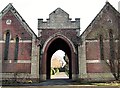
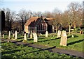
Entrance to Snatt's Road cemetery, Uckfield
Also known as Uckfield Cemetery and established in the late 19th century.
Image: © Patrick Roper
Taken: 6 Feb 2007
0.16 miles
10
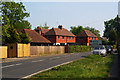
London Road, Ringles Cross, Sussex
Looking in the direction of Uckfield. The town sign can be seen, to the right of picture.
Image: © Peter Trimming
Taken: 26 Apr 2011
0.16 miles