IMAGES TAKEN NEAR TO
Views Wood Path, UCKFIELD, TN22 1JL
Introduction
This page details the photographs taken nearby to Views Wood Path, TN22 1JL by members of the Geograph project.
The Geograph project started in 2005 with the aim of publishing, organising and preserving representative images for every square kilometre of Great Britain, Ireland and the Isle of Man.

There are currently over 7.5m images from over14,400 individuals and you can help contribute to the project by visiting https://www.geograph.org.uk
Image Map
Images are licensed for reuse under creativecommons.org/licenses/by-sa/2.0
Notes
- Clicking on the map will re-center to the selected point.
- The higher the marker number, the further away the image location is from the centre of the postcode.
Image Listing (19 Images Found)
Images are licensed for reuse under creativecommons.org/licenses/by-sa/2.0
Image
Details
Distance
1
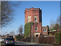
Water Tower on Brown Lane
Built in 1903.
Image: © Oast House Archive
Taken: 7 Mar 2010
0.13 miles
2
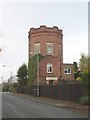
Water tower
I assume this is a water tower converted to a residence.
Image: © Mike Stace
Taken: 4 Nov 2008
0.13 miles
3
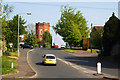
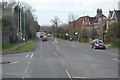
Brown Lane, Uckfield, Sussex
Looking in the direction of the water tower, from London Road.
Image: © Peter Trimming
Taken: 26 Apr 2011
0.13 miles
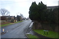
6
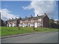
Manor Park housing estate
A large housing estate to the west of Uckfield.
Image: © Nigel Freeman
Taken: 29 Sep 2005
0.17 miles
7
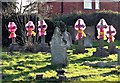
Gravestones marked as dangerous (of toppling), Uckfield
This was in the Snatt's Road Cemetery also called Uckfield Cemetery
Image: © Patrick Roper
Taken: 6 Feb 2007
0.20 miles
8

Bluauto
See also Image for an earlier version of this building.
Image: © N Chadwick
Taken: 23 Jan 2016
0.20 miles
10
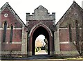
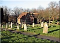
Entrance to Snatt's Road cemetery, Uckfield
Also known as Uckfield Cemetery and established in the late 19th century.
Image: © Patrick Roper
Taken: 6 Feb 2007
0.20 miles