IMAGES TAKEN NEAR TO
Observatory Road, HEATHFIELD, TN21 9LN
Introduction
This page details the photographs taken nearby to Observatory Road, TN21 9LN by members of the Geograph project.
The Geograph project started in 2005 with the aim of publishing, organising and preserving representative images for every square kilometre of Great Britain, Ireland and the Isle of Man.

There are currently over 7.5m images from over14,400 individuals and you can help contribute to the project by visiting https://www.geograph.org.uk
Image Map (Loading...)


Getting Data...Please wait
Leaflet Map data © OpenStreetMap
Images are licensed for reuse under creativecommons.org/licenses/by-sa/2.0
Notes
- Clicking on the map will re-center to the selected point.
- The higher the marker number, the further away the image location is from the centre of the postcode.
Image Listing (7 Images Found)
Images are licensed for reuse under creativecommons.org/licenses/by-sa/2.0
Image
Details
Distance
1
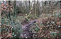
Path Junction
A path junction in the woodland near to Brightling Down Farm.
Image: © Chris Thomas-Atkin
Taken: 6 Jan 2019
0.08 miles
2
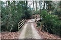
Boardwalk on the footpath
A section of boardwalk on the public footpath through the woodland near Brightling Down Farm.
Image: © Chris Thomas-Atkin
Taken: 6 Jan 2019
0.09 miles
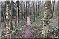
3
Path junction at Brightling Down
A meeting of four ways.
Image: © Chris Thomas-Atkin
Taken: 6 Jan 2019
0.14 miles
4
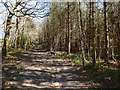
Upper Plantation
Located to the south of Brightling 29b public bridleway on Brightling Down.
Image: © Simon Carey
Taken: 22 Mar 2020
0.16 miles
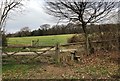
5
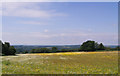
Wild Flower Meadow - Brightling Down
A view to the west across Brightling Down, Sussex
Image: © John Winfield
Taken: 12 Aug 2007
0.17 miles
6
Bridge near Beggars Well
The bridge across a small stream close to Beggars Well.
Image: © Chris Thomas-Atkin
Taken: 6 Jan 2019
0.21 miles
7
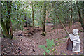
Statue in the woods
It was a surprise to come across this cherub at the edge of Lower Plantation woods. A tributary of the Willingford stream at the bottom of the slope was all but dry.
Image: © Julian P Guffogg
Taken: 21 Aug 2011
0.24 miles