IMAGES TAKEN NEAR TO
Dallington, HEATHFIELD, TN21 9JG
Introduction
This page details the photographs taken nearby to TN21 9JG by members of the Geograph project.
The Geograph project started in 2005 with the aim of publishing, organising and preserving representative images for every square kilometre of Great Britain, Ireland and the Isle of Man.

There are currently over 7.5m images from over14,400 individuals and you can help contribute to the project by visiting https://www.geograph.org.uk
Image Map (Loading...)


Getting Data...Please wait
Leaflet Map data © OpenStreetMap
Images are licensed for reuse under creativecommons.org/licenses/by-sa/2.0
Notes
- Clicking on the map will re-center to the selected point.
- The higher the marker number, the further away the image location is from the centre of the postcode.
Image Listing (19 Images Found)
Images are licensed for reuse under creativecommons.org/licenses/by-sa/2.0
Image
Details
Distance
1
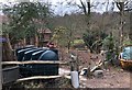
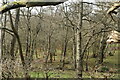
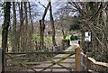
Cottage near Cox?s Mill
The local maps record this as being Dabchick Cottage.
Image: © Chris Thomas-Atkin
Taken: 6 Jan 2019
0.01 miles
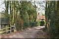
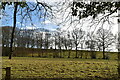
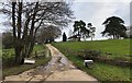
9
Cox?s Mill
Looking along the track to Cox’s Mill. The mill building is a Grade II listed building.
Image: © Chris Thomas-Atkin
Taken: 6 Jan 2019
0.14 miles
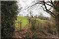
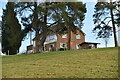
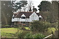
10
Brooklands Farm
Hill House, Brooklands Farm and the approaching driveway.
Image: © Chris Thomas-Atkin
Taken: 6 Jan 2019
0.14 miles