IMAGES TAKEN NEAR TO
Vines Cross, HEATHFIELD, TN21 9HA
Introduction
This page details the photographs taken nearby to TN21 9HA by members of the Geograph project.
The Geograph project started in 2005 with the aim of publishing, organising and preserving representative images for every square kilometre of Great Britain, Ireland and the Isle of Man.

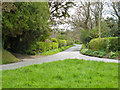
There are currently over 7.5m images from over14,400 individuals and you can help contribute to the project by visiting https://www.geograph.org.uk
Image Map (Loading...)


Getting Data...Please wait
Leaflet Map data © OpenStreetMap
Images are licensed for reuse under creativecommons.org/licenses/by-sa/2.0
Notes
- Clicking on the map will re-center to the selected point.
- The higher the marker number, the further away the image location is from the centre of the postcode.
Image Listing (21 Images Found)
Images are licensed for reuse under creativecommons.org/licenses/by-sa/2.0
Image
Details
Distance
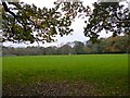
1
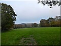
Middle Field
The name of the field according to Warbleton's 1838 tithe map located to the north of Foords Lane now used as a camping field owned by Wimbles Farm.
Image: © Simon Carey
Taken: 12 Nov 2022
0.07 miles
2
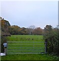
North Field
The name of the field according to Warbleton's 1838 tithe map that is bounded to the west by Foords Lane and is now used as a campsite operating out of Wimbles Farm.
Image: © Simon Carey
Taken: 12 Nov 2022
0.09 miles
3
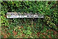
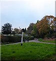
Old Direction Sign - Signpost by Foords Lane, Warbleton parish
No finial - 2 arms; East Sussex simple wood by the UC road, in parish of Warbleton (Wealden District), junction of Foords Lane and Clapper Lane with Cowden Hall Lane, against hedge on East side of Foords Lane away from the grass triangle in the middle of the junction.
Surveyed
Milestone Society National ID: SX_TQ6016A
Image: © Milestone Society
Taken: Unknown
0.09 miles
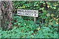
5
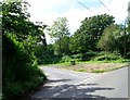
Cowden Hall Lane
A single track lane heading south from the junction with Clappers Lane and Foords Lane to Marle Green.
Image: © Simon Carey
Taken: 12 Nov 2022
0.10 miles
6
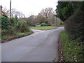
No signpost at the junction Cowden Hall Lane and Foords Lane
Image: © Dave Spicer
Taken: 21 Nov 2010
0.10 miles
7
Old Direction Sign - Signpost by Cowden Hall Lane, Warbleton Parish
No finial - 1 arm; East Sussex simple wood by the UC road, in parish of Warbleton (Wealden District), junction of Foords Lane and Cappers Lane with Cowden Hall Lane, against hedge at side of Cowden Hall Lane, away from the grass triangle which is in the middle of the junction.
Surveyed
Milestone Society National ID: SX_TQ6016B.
Image: © Milestone Society
Taken: Unknown
0.10 miles
8
Great Gate Field
The name of the field according to Heathfield's 1841 tithe map that is bounded by Foords Lane to the east and Clappers Wood to the west and north.
Image: © Simon Carey
Taken: 12 Nov 2022
0.11 miles
9
At the junction
The junction is of Cowden Hall Lane to the right and a lane possibly called Foords Lane - it certainly is called that at its north end. There is a grass triangle here, lacking the usual signpost.
Image: © Robin Webster
Taken: 21 Apr 2012
0.12 miles
10
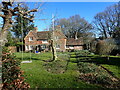
House seen from Cowden Hall Lane
This attractive house is at the junction of Cowden Hall Lane with Foords Lane.
Image: © Marathon
Taken: 27 Feb 2022
0.12 miles