IMAGES TAKEN NEAR TO
Punnetts Town, HEATHFIELD, TN21 9DH
Introduction
This page details the photographs taken nearby to TN21 9DH by members of the Geograph project.
The Geograph project started in 2005 with the aim of publishing, organising and preserving representative images for every square kilometre of Great Britain, Ireland and the Isle of Man.

There are currently over 7.5m images from over14,400 individuals and you can help contribute to the project by visiting https://www.geograph.org.uk
Image Map (Loading...)


Getting Data...Please wait
Leaflet Map data © OpenStreetMap
Images are licensed for reuse under creativecommons.org/licenses/by-sa/2.0
Notes
- Clicking on the map will re-center to the selected point.
- The higher the marker number, the further away the image location is from the centre of the postcode.
Image Listing (26 Images Found)
Images are licensed for reuse under creativecommons.org/licenses/by-sa/2.0
Image
Details
Distance
3
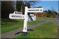
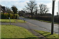
Old Direction Sign - Signpost by the B2096, Heathfield and Waldron Parish
Black iron cap finial - 3 arms; East Sussex wood with number by the B2096, in parish of Heathfield and Waldron (Wealden District), B2096, on verge opposite junction of Barleymow Lane with B2096.
Surveyed
Milestone Society National ID: SX_TQ6220
Image: © Milestone Society
Taken: Unknown
0.09 miles
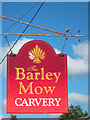
5
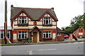
The Barley Mow Pub
Also a carvery.
Image: © Julian P Guffogg
Taken: 17 Jul 2011
0.10 miles
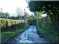
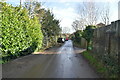
10
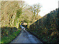
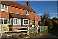
Upper Greenwoods Lane
One of the lanes of Punnett's Town.
Image: © Robin Webster
Taken: 7 Dec 2012
0.17 miles