IMAGES TAKEN NEAR TO
Walnut Close, HEATHFIELD, TN21 8YL
Introduction
This page details the photographs taken nearby to Walnut Close, TN21 8YL by members of the Geograph project.
The Geograph project started in 2005 with the aim of publishing, organising and preserving representative images for every square kilometre of Great Britain, Ireland and the Isle of Man.

There are currently over 7.5m images from over14,400 individuals and you can help contribute to the project by visiting https://www.geograph.org.uk
Image Map (Loading...)


Getting Data...Please wait
Leaflet Map data © OpenStreetMap
Images are licensed for reuse under creativecommons.org/licenses/by-sa/2.0
Notes
- Clicking on the map will re-center to the selected point.
- The higher the marker number, the further away the image location is from the centre of the postcode.
Image Listing (3 Images Found)
Images are licensed for reuse under creativecommons.org/licenses/by-sa/2.0
Image
Details
Distance
1
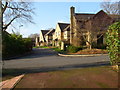
Bay Tree Close, Heathfield
Bay Tree Close in the 'newer' part of Heathfield is typical of the housing built on the 'Green Lane' estate during 1989. It would be good to see some photos of the area prior to this development.
Image: © David Harvey
Taken: 2 Jan 2008
0.11 miles
2
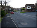
Woodland Way - Heathfield
Woodland Way in the 'newer' part of Heathfield is typical of the housing built on the 'Green Lane' estate during 1989. It would be good to see some photos of the area prior to this development.
Image: © David Harvey
Taken: 12 Jan 2008
0.22 miles
3
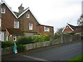
Green Lane, Heathfield - November 2006
The large house pictured has now been demolished and replaced with 'Sunfields' development.
Image: © David Harvey
Taken: 24 Nov 2006
0.22 miles