IMAGES TAKEN NEAR TO
Burwash Road, HEATHFIELD, TN21 8QU
Introduction
This page details the photographs taken nearby to Burwash Road, TN21 8QU by members of the Geograph project.
The Geograph project started in 2005 with the aim of publishing, organising and preserving representative images for every square kilometre of Great Britain, Ireland and the Isle of Man.

There are currently over 7.5m images from over14,400 individuals and you can help contribute to the project by visiting https://www.geograph.org.uk
Image Map (Loading...)


Getting Data...Please wait
Leaflet Map data © OpenStreetMap
Images are licensed for reuse under creativecommons.org/licenses/by-sa/2.0
Notes
- Clicking on the map will re-center to the selected point.
- The higher the marker number, the further away the image location is from the centre of the postcode.
Image Listing (20 Images Found)
Images are licensed for reuse under creativecommons.org/licenses/by-sa/2.0
Image
Details
Distance
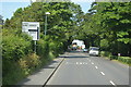
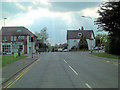
2
Vines Corner
Looking down Marklye Lane to the crossroads with the A267 and B2203 and Mutton Hall Road.
Image: © Simon Carey
Taken: 23 May 2009
0.02 miles
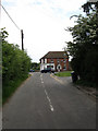
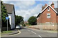
3
Road Junction with Traffic Lights
The junction of the A265 and the B2203 at the Eastern end of Heathfield.
Image: © Chris Thomas-Atkin
Taken: 29 Apr 2018
0.03 miles
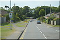
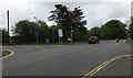
10
Northdown beside Newick Lane
Approaching the road junction with the A265.
Image: © Chris Thomas-Atkin
Taken: 29 Apr 2018
0.17 miles