IMAGES TAKEN NEAR TO
Firwood Rise, HEATHFIELD, TN21 8NP
Introduction
This page details the photographs taken nearby to Firwood Rise, TN21 8NP by members of the Geograph project.
The Geograph project started in 2005 with the aim of publishing, organising and preserving representative images for every square kilometre of Great Britain, Ireland and the Isle of Man.

There are currently over 7.5m images from over14,400 individuals and you can help contribute to the project by visiting https://www.geograph.org.uk
Image Map
Images are licensed for reuse under creativecommons.org/licenses/by-sa/2.0
Notes
- Clicking on the map will re-center to the selected point.
- The higher the marker number, the further away the image location is from the centre of the postcode.
Image Listing (7 Images Found)
Images are licensed for reuse under creativecommons.org/licenses/by-sa/2.0
Image
Details
Distance

4
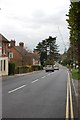
Heathfield High Street
Looking towards the Library on the High Street.
Image: © Chris Thomas-Atkin
Taken: 29 Apr 2018
0.22 miles
5
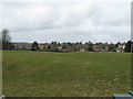
View NW across Heathfield from the recreation ground
In the distance is the tall TV and radio mast at Cross in Hand.
Image: © Dave Spicer
Taken: 15 Apr 2013
0.23 miles
6
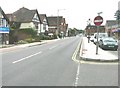
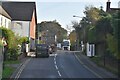
High Street (A265), Heathfield
Looking southwest with the town's sign set in the pavement and visible behind the no entry road sign.
Image: © John Baker
Taken: 3 Jul 2011
0.25 miles
7
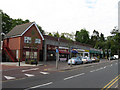
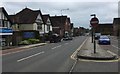
New Parade
Off the High Street and the eastern end of the line of shops in the town. Mr India and Pizza provide for your takeaway needs, William Hill and Personal Touch for interior decorating, Shoeby Doo and Chaps Barbers deal with the extremities of the human body, whilst Thresher provide the goods when the rest gets too much for you.
Image: © Simon Carey
Taken: 23 May 2009
0.25 miles