IMAGES TAKEN NEAR TO
Churchill Road, HEATHFIELD, TN21 8BA
Introduction
This page details the photographs taken nearby to Churchill Road, TN21 8BA by members of the Geograph project.
The Geograph project started in 2005 with the aim of publishing, organising and preserving representative images for every square kilometre of Great Britain, Ireland and the Isle of Man.

There are currently over 7.5m images from over14,400 individuals and you can help contribute to the project by visiting https://www.geograph.org.uk
Image Map (Loading...)


Getting Data...Please wait
Leaflet Map data © OpenStreetMap
Images are licensed for reuse under creativecommons.org/licenses/by-sa/2.0
Notes
- Clicking on the map will re-center to the selected point.
- The higher the marker number, the further away the image location is from the centre of the postcode.
Image Listing (33 Images Found)
Images are licensed for reuse under creativecommons.org/licenses/by-sa/2.0
Image
Details
Distance
1
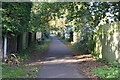
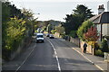
Green Lane, Heathfield - November 2006
The large house pictured has now been demolished and replaced with 'Sunfields' development.
Image: © David Harvey
Taken: 24 Nov 2006
0.05 miles
2
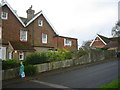
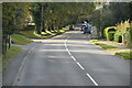
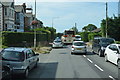
Hailsham Road, Heathfield
B2203 south of the town centre.
Image: © Des Blenkinsopp
Taken: 2 Jan 2025
0.09 miles
4
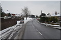
Hailsham Road, Heathfield
The first snow of 2013.
Image: © Julian P Guffogg
Taken: 19 Jan 2013
0.11 miles
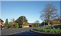
8
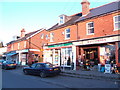
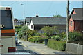
Sandy Cross Post Office
With parade of shops on the B2203 Horam Road.
Image: © Jonathan Billinger
Taken: 6 Feb 2007
0.16 miles