IMAGES TAKEN NEAR TO
Meadow Way, HEATHFIELD, TN21 8AJ
Introduction
This page details the photographs taken nearby to Meadow Way, TN21 8AJ by members of the Geograph project.
The Geograph project started in 2005 with the aim of publishing, organising and preserving representative images for every square kilometre of Great Britain, Ireland and the Isle of Man.

There are currently over 7.5m images from over14,400 individuals and you can help contribute to the project by visiting https://www.geograph.org.uk
Image Map
Images are licensed for reuse under creativecommons.org/licenses/by-sa/2.0
Notes
- Clicking on the map will re-center to the selected point.
- The higher the marker number, the further away the image location is from the centre of the postcode.
Image Listing (36 Images Found)
Images are licensed for reuse under creativecommons.org/licenses/by-sa/2.0
Image
Details
Distance
1
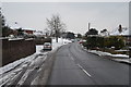
Hailsham Road, Heathfield
The first snow of 2013.
Image: © Julian P Guffogg
Taken: 19 Jan 2013
0.05 miles
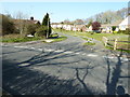
2
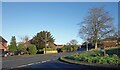
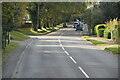
Hailsham Road, Heathfield
B2203 south of the town centre.
Image: © Des Blenkinsopp
Taken: 2 Jan 2025
0.05 miles
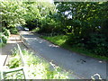
5
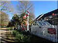
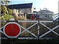
Frenches Halt on the Cuckoo Trail
This is on the Cuckoo Trail which is an 18 mile long cycling and walking route between Heathfield and Polegate in East Sussex on a former railway known as the Cuckoo Line. It became known as the Cuckoo Line because traditionally, the first cuckoo of spring was released from a cage at Heathfield Fair. The section here was opened on 1st September 1880 and closed to passengers on 9th September 1968.
The signal can be operated by passers by. Both the level crossing gates and the signal box are replacements - see https://www.geograph.org.uk/photo/7107367
Image: © Marathon
Taken: 27 Feb 2022
0.08 miles
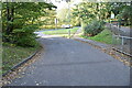
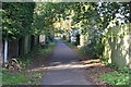
7
Swaines Way Heathfield
The Cuckoo Trail pathway is behind the bungalows on the right.
Image: © Dave Spicer
Taken: 2 Apr 2012
0.09 miles
8
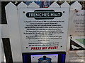
Information about Frenches Halt on the Cuckoo Trail
This is on the Cuckoo Trail which is an 18 mile long cycling and walking route between Heathfield and Polegate in East Sussex on a former railway known as the Cuckoo Line. It became known as the Cuckoo Line because traditionally, the first cuckoo of spring was released from a cage at Heathfield Fair. The section here was opened on 1st September 1880 and closed to passengers on 9th September 1968.
See https://www.geograph.org.uk/photo/7107365 for a photograph of Frenches Halt.
Image: © Marathon
Taken: 27 Feb 2022
0.10 miles
10
Frenches Halt on the Cuckoo Trail
This is on the Cuckoo Trail which is an 18 mile long cycling and walking route between Heathfield and Polegate in East Sussex on a former railway known as the Cuckoo Line. It became known as the Cuckoo Line because traditionally, the first cuckoo of spring was released from a cage at Heathfield Fair. The section here was opened on 1st September 1880 and closed to passengers on 9th September 1968.
A signal can be operated by passers by. Both the level crossing gates and the signal box are replacements - see https://www.geograph.org.uk/photo/7107367 For another view of Frenches Halt see https://www.geograph.org.uk/photo/7107369
Image: © Marathon
Taken: 27 Feb 2022
0.11 miles