IMAGES TAKEN NEAR TO
Firgrove Road, HEATHFIELD, TN21 0QN
Introduction
This page details the photographs taken nearby to Firgrove Road, TN21 0QN by members of the Geograph project.
The Geograph project started in 2005 with the aim of publishing, organising and preserving representative images for every square kilometre of Great Britain, Ireland and the Isle of Man.

There are currently over 7.5m images from over14,400 individuals and you can help contribute to the project by visiting https://www.geograph.org.uk
Image Map (Loading...)


Getting Data...Please wait
Leaflet Map data © OpenStreetMap
Images are licensed for reuse under creativecommons.org/licenses/by-sa/2.0
Notes
- Clicking on the map will re-center to the selected point.
- The higher the marker number, the further away the image location is from the centre of the postcode.
Image Listing (36 Images Found)
Images are licensed for reuse under creativecommons.org/licenses/by-sa/2.0
Image
Details
Distance

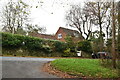
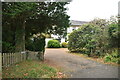
3

Track to Selwyns Wood Nature Reserve
On Fir Grove Road looking towards the track to the Nature Reserve.
Image: © Chris Thomas-Atkin
Taken: 25 May 2018
0.01 miles
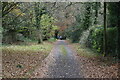
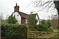
4
Selwyns Wood Nature Reserve entrance road, Roser's Cross, East Sussex
The reserve belongs to the Sussex Wildlife Trust and consists of 11 hectares of woodland.
Image: © nick macneill
Taken: 19 Nov 2009
0.03 miles
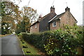
7
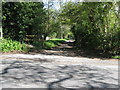
Selwyns Wood Nature Reserve
Run by the Woodland Trust.
Image: © Dave Spicer
Taken: 3 May 2010
0.06 miles
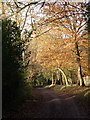
8
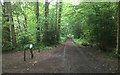
Selwyns Wood Car Park
The car park at Selwyns Wood Nature Reserve.
Image: © Chris Thomas-Atkin
Taken: 25 May 2018
0.07 miles