IMAGES TAKEN NEAR TO
Dern Lane, HEATHFIELD, TN21 0PN
Introduction
This page details the photographs taken nearby to Dern Lane, TN21 0PN by members of the Geograph project.
The Geograph project started in 2005 with the aim of publishing, organising and preserving representative images for every square kilometre of Great Britain, Ireland and the Isle of Man.

There are currently over 7.5m images from over14,400 individuals and you can help contribute to the project by visiting https://www.geograph.org.uk
Image Map (Loading...)


Getting Data...Please wait
Leaflet Map data © OpenStreetMap
Images are licensed for reuse under creativecommons.org/licenses/by-sa/2.0
Notes
- Clicking on the map will re-center to the selected point.
- The higher the marker number, the further away the image location is from the centre of the postcode.
Image Listing (26 Images Found)
Images are licensed for reuse under creativecommons.org/licenses/by-sa/2.0
Image
Details
Distance
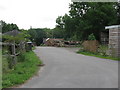
1
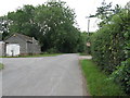
Opposing farms off Dern Lane
Little Dernwood Farm has a small campsite in its grounds.
Image: © Dave Spicer
Taken: 15 Aug 2010
0.03 miles
3
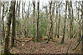
Summersbrook Wood
The eastern end of the wood that borders Dern Lane.
Image: © Simon Carey
Taken: 17 Dec 2022
0.08 miles
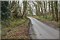
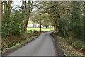
7
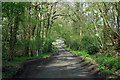
Dern Lane in Little Dern Wood
Summersbrook Farm is just showing beyond the wood.
Image: © Robin Webster
Taken: 17 Apr 2012
0.12 miles
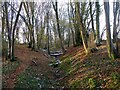
8
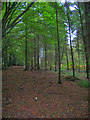
Great Dern Wood
With obligatory discarded empty can of Stella in the foreground.
Image: © Simon Carey
Taken: 26 Oct 2006
0.12 miles
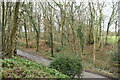
10
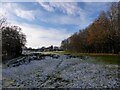
Little Dern Wood
The wood once occupied the land up to Copford Farm in the distance but much has now been cleared except for a section adjacent to Dern Lane on the right.
Image: © Simon Carey
Taken: 17 Dec 2022
0.13 miles