IMAGES TAKEN NEAR TO
Waldron, HEATHFIELD, TN21 0NL
Introduction
This page details the photographs taken nearby to TN21 0NL by members of the Geograph project.
The Geograph project started in 2005 with the aim of publishing, organising and preserving representative images for every square kilometre of Great Britain, Ireland and the Isle of Man.

There are currently over 7.5m images from over14,400 individuals and you can help contribute to the project by visiting https://www.geograph.org.uk
Image Map (Loading...)


Getting Data...Please wait
Leaflet Map data © OpenStreetMap
Images are licensed for reuse under creativecommons.org/licenses/by-sa/2.0
Notes
- Clicking on the map will re-center to the selected point.
- The higher the marker number, the further away the image location is from the centre of the postcode.
Image Listing (34 Images Found)
Images are licensed for reuse under creativecommons.org/licenses/by-sa/2.0
Image
Details
Distance
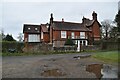
1
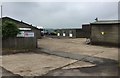
Burnt Oak Farm
Burnt Oak Farm and Business Park.
Image: © Chris Thomas-Atkin
Taken: 25 May 2018
0.02 miles
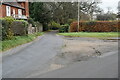
5
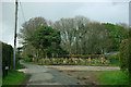
Junction of Burnt Oak Lane and another lane
The lane to the right does not declare its name.
Image: © Robin Webster
Taken: 17 Apr 2012
0.04 miles
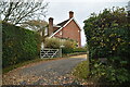
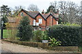
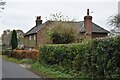
8
Burnt Oak Cottage
Burnt Oak Lane to the left doubles back to Little London whilst Back Lane to the right heads to Lions Green.
Image: © Simon Carey
Taken: 26 Oct 2006
0.06 miles
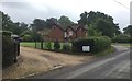
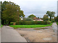
10
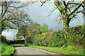
April shower ahead
An unexpected sunny window in the afternoon is drawing to a close along this lane that is coy about its name.
Image: © Robin Webster
Taken: 17 Apr 2012
0.09 miles