IMAGES TAKEN NEAR TO
Swansbrook Lane, HEATHFIELD, TN21 0LB
Introduction
This page details the photographs taken nearby to Swansbrook Lane, TN21 0LB by members of the Geograph project.
The Geograph project started in 2005 with the aim of publishing, organising and preserving representative images for every square kilometre of Great Britain, Ireland and the Isle of Man.

There are currently over 7.5m images from over14,400 individuals and you can help contribute to the project by visiting https://www.geograph.org.uk
Image Map
Images are licensed for reuse under creativecommons.org/licenses/by-sa/2.0
Notes
- Clicking on the map will re-center to the selected point.
- The higher the marker number, the further away the image location is from the centre of the postcode.
Image Listing (66 Images Found)
Images are licensed for reuse under creativecommons.org/licenses/by-sa/2.0
Image
Details
Distance
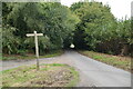
1
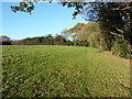
Barn Field
The name of the field according to Chiddingly's 1839 tithe map. Swansbrook Lane is beyond the hedge at the far end of the field.
Image: © Simon Carey
Taken: 19 Feb 2012
0.06 miles
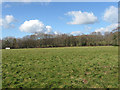
2
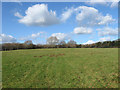
Cricket Field
The name of the field according to Chiddingly's 1839 tithe map now subdivided by a wooden fence.
Image: © Simon Carey
Taken: 19 Feb 2012
0.06 miles
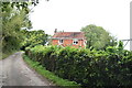
4
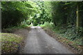
Price's Farm
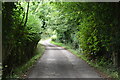
On Swansbrook Lane between Gun Hill and Cogger's Cross. The yellow flowers are children's windmills.
Image: © Simon Carey
Taken: 26 Oct 2006
0.08 miles
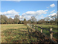
7
Footway Field
The name of the field according to Chiddingly's 1839 tithe map and named after two footpaths that run through the field.
Image: © Simon Carey
Taken: 19 Feb 2012
0.09 miles
9
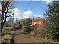
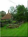
Malvern Farmhouse
Formerly known as Beeney's Farm.
Image: © Simon Carey
Taken: 19 Feb 2012
0.10 miles