IMAGES TAKEN NEAR TO
Gun Hill, HEATHFIELD, TN21 0LA
Introduction
This page details the photographs taken nearby to TN21 0LA by members of the Geograph project.
The Geograph project started in 2005 with the aim of publishing, organising and preserving representative images for every square kilometre of Great Britain, Ireland and the Isle of Man.

There are currently over 7.5m images from over14,400 individuals and you can help contribute to the project by visiting https://www.geograph.org.uk
Image Map (Loading...)


Getting Data...Please wait
Leaflet Map data © OpenStreetMap
Images are licensed for reuse under creativecommons.org/licenses/by-sa/2.0
Notes
- Clicking on the map will re-center to the selected point.
- The higher the marker number, the further away the image location is from the centre of the postcode.
Image Listing (28 Images Found)
Images are licensed for reuse under creativecommons.org/licenses/by-sa/2.0
Image
Details
Distance
1
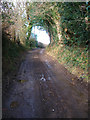
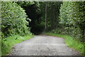
Farmtrack to Rock Harbour Farm
Beginning at World's End the track serves a number of farms before meeting Swansbrook Lane to the north east. This section is between Popp's Farm and Rock Harbour Farm with the holloway suggesting usage over a long period of time.
Image: © Simon Carey
Taken: 3 Mar 2007
0.06 miles
2
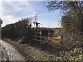
Official path diversion
The public footpath leaves the track to Nut Knowles Farm World’s End on an official diversion passing round the farm.
Image: © Chris Thomas-Atkin
Taken: 17 Feb 2019
0.09 miles
3
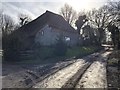
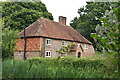
Barn at Rock Harbour Farm
An old barn at Rock Harbour Farm, which is a Grade II listed building, viewed from the public footpath.
Image: © Chris Thomas-Atkin
Taken: 17 Feb 2019
0.11 miles
4
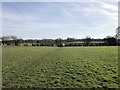
The Wealdway
On the Wealdway just past Rock Harbour Farm heading southeastwards.
Image: © Chris Thomas-Atkin
Taken: 17 Feb 2019
0.13 miles
6

Old Lace Wood
Actually a newly planted small area of woodland on a former field called Spring Field according to Chiddingly's 1839 tithe map.
Image: © Simon Carey
Taken: 19 Feb 2012
0.14 miles
8
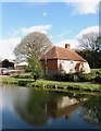
West Street Farm
The farmhouse dates from the 17th century.
Image: © Simon Carey
Taken: 19 Feb 2012
0.16 miles
10
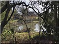
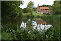
Glimpse of a pond
A pond at West Street Farm viewed through the trees from the passing public footpath.
Image: © Chris Thomas-Atkin
Taken: 17 Feb 2019
0.17 miles