IMAGES TAKEN NEAR TO
Westwood Mews, HEATHFIELD, TN21 0DQ
Introduction
This page details the photographs taken nearby to Westwood Mews, TN21 0DQ by members of the Geograph project.
The Geograph project started in 2005 with the aim of publishing, organising and preserving representative images for every square kilometre of Great Britain, Ireland and the Isle of Man.

There are currently over 7.5m images from over14,400 individuals and you can help contribute to the project by visiting https://www.geograph.org.uk
Image Map (Loading...)


Getting Data...Please wait
Leaflet Map data © OpenStreetMap
Images are licensed for reuse under creativecommons.org/licenses/by-sa/2.0
Notes
- Clicking on the map will re-center to the selected point.
- The higher the marker number, the further away the image location is from the centre of the postcode.
Image Listing (80 Images Found)
Images are licensed for reuse under creativecommons.org/licenses/by-sa/2.0
Image
Details
Distance
1
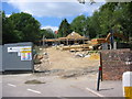
Westwood Cars site under redevelopment
Image: © David Harvey
Taken: 11 Jul 2006
0.01 miles
2
Demolition of former new Temperance hotel
Demolition of Westwood Motors (formerly new Temperance hotel) as photographed on April 6th 2006.
Image: © David Harvey
Taken: 6 Apr 2006
0.02 miles
4
Former Westwood Cars site being redeveloped
Image: © David Harvey
Taken: 21 Oct 2006
0.02 miles
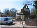
5

Westwood cars premises before re-development
Westwood cars premises photographed on August 21st 2005 before redevelopment. The building on the right was known as the new Temperance Hotel, built in 1924 for Mrs Mary Avard. She ran the tea rooms which was used by travellers from the railway station opposite. Her son Bill ran a taxi service from the building on the left which apparently housed the first petrol pump in Heathfield.
Image: © David Harvey
Taken: 21 Aug 2005
0.02 miles
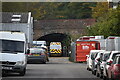
6
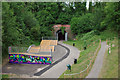
Heathfield Tunnel and skateboard park
Viewed from the bridge carrying Station Approach over the former railway line.
Image: © Robin Webster
Taken: 5 Jul 2010
0.02 miles
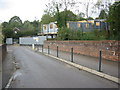
7
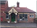
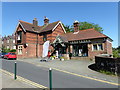
Old railway station, Heathfield
This disused railway station, close to the entrance of old Heathfield tunnel, is now a kitchenware shop.
Image: © Patrick GUEULLE
Taken: 27 May 2007
0.03 miles
8
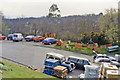
Car park on the site of Heathfield station
View southward, towards Polegate (and Eastbourne), on the ex-LB&SCR (London - Oxted -) Eridge - Polegate ('Cuckoo') line, closed 14/6/65 Eridge - Hailsham, 9/9/68 Hailsham - Polegate.
Image: © Ben Brooksbank
Taken: 24 Mar 1993
0.05 miles
10
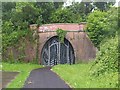
Mouth of old Heathfield tunnel
This disused 240 m tunnel under the Co-Op supermarket at Heathfield looks exactly like the one in Enid Blyton's "Five go off to camp", but without the "spook train" !
Image: © Patrick GUEULLE
Taken: 27 May 2007
0.05 miles