IMAGES TAKEN NEAR TO
Fletching Street, MAYFIELD, TN20 6TN
Introduction
This page details the photographs taken nearby to Fletching Street, TN20 6TN by members of the Geograph project.
The Geograph project started in 2005 with the aim of publishing, organising and preserving representative images for every square kilometre of Great Britain, Ireland and the Isle of Man.

There are currently over 7.5m images from over14,400 individuals and you can help contribute to the project by visiting https://www.geograph.org.uk
Image Map (Loading...)


Getting Data...Please wait
Leaflet Map data © OpenStreetMap
Images are licensed for reuse under creativecommons.org/licenses/by-sa/2.0
Notes
- Clicking on the map will re-center to the selected point.
- The higher the marker number, the further away the image location is from the centre of the postcode.
Image Listing (113 Images Found)
Images are licensed for reuse under creativecommons.org/licenses/by-sa/2.0
Image
Details
Distance

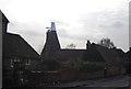
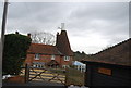
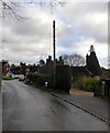
4
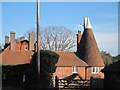
The Oast, Fletching Street, Mayfield
The cowl has been re-added since Image
Image: © Oast House Archive
Taken: 27 Nov 2011
0.02 miles
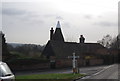
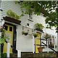
6
The Oast House on Fletching Street
Image: © Chris Thomas-Atkin
Taken: 13 Jan 2019
0.02 miles
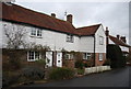
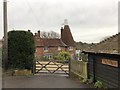
8
The Oast, Fletching Street, Mayfield
Once belonging to Yew Tree Farm, now converted into a residence.
Image: © Simon Carey
Taken: 29 Dec 2022
0.02 miles