IMAGES TAKEN NEAR TO
Witherenden Road, MAYFIELD, TN20 6RP
Introduction
This page details the photographs taken nearby to Witherenden Road, TN20 6RP by members of the Geograph project.
The Geograph project started in 2005 with the aim of publishing, organising and preserving representative images for every square kilometre of Great Britain, Ireland and the Isle of Man.

There are currently over 7.5m images from over14,400 individuals and you can help contribute to the project by visiting https://www.geograph.org.uk
Image Map (16 Images)


Getting Data...Please wait
Leaflet Map data © OpenStreetMap
Images are licensed for reuse under creativecommons.org/licenses/by-sa/2.0
Notes
- Clicking on the map will re-center to the selected point.
- The higher the marker number, the further away the image location is from the centre of the postcode.
Image Listing (16 Images Found)
Images are licensed for reuse under creativecommons.org/licenses/by-sa/2.0
Image
Details
Distance
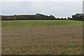
1
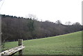
Little Poundgate Field
The name of the field according to Mayfield's 1844 tithe map located to the south of Winter's Farm.
Image: © Simon Carey
Taken: 29 Dec 2022
0.04 miles
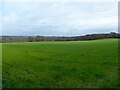
2
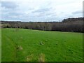
Hollow Field
The name of the field according to Mayfield's 1844 tithe map bounded by Hawksden Park Wood to the east.
Image: © Simon Carey
Taken: 29 Dec 2022
0.08 miles
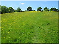
3
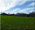
Winter Meadow
The name of the field according to Mayfield's 1844 tithe map that is bounded by Winter's Shaw to the west and Winter's Farm to the south.
Image: © Simon Carey
Taken: 29 Dec 2022
0.08 miles
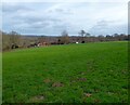
4
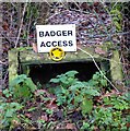
Badger Access, Winter's Farm
I'm assuming those erecting the sign believe the badgers will read it. Meanwhile do the badgers follow the footpath direction once through the tunnel.
Image: © Simon Carey
Taken: 29 Dec 2022
0.09 miles
5
The path to Winters Farm
Leads south from the more popular paths in the Bivelham valley.
Image: © David M Clark
Taken: 26 May 2020
0.12 miles
6
Poundgate Field
The name of the field according to Mayfield's 1844 tithe map that is bounded by Witherenden Road to the south and Hawksden Park Wood to the east. The field's name likely derives from the time when Hawksden deer park was in existence and allowed some commoners grazing rights within its boundaries. Any stray animal would be interred in a pound until the owner claimed it, the pound for the deer park was probably on the edge of the wood.
Image: © Simon Carey
Taken: 29 Dec 2022
0.14 miles
8
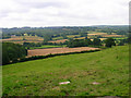
The Weald
Taken from the point where the footpath from Street End Lane meets Witherenden Lane. The latter like many routes in this part of the country follows the ridge of a hill avoiding the wetter lower levels. The patchwork of small fields were hacked out of the forest in the early middle ages.
Image: © Simon Carey
Taken: 25 Jul 2007
0.19 miles