IMAGES TAKEN NEAR TO
Lake Street, MAYFIELD, TN20 6PR
Introduction
This page details the photographs taken nearby to Lake Street, TN20 6PR by members of the Geograph project.
The Geograph project started in 2005 with the aim of publishing, organising and preserving representative images for every square kilometre of Great Britain, Ireland and the Isle of Man.

There are currently over 7.5m images from over14,400 individuals and you can help contribute to the project by visiting https://www.geograph.org.uk
Image Map (Loading...)


Getting Data...Please wait
Leaflet Map data © OpenStreetMap
Images are licensed for reuse under creativecommons.org/licenses/by-sa/2.0
Notes
- Clicking on the map will re-center to the selected point.
- The higher the marker number, the further away the image location is from the centre of the postcode.
Image Listing (3 Images Found)
Images are licensed for reuse under creativecommons.org/licenses/by-sa/2.0
Image
Details
Distance
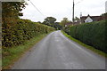
1
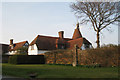
The Oast, Lake Street, Tidebrook, Mayfield, East Sussex
Image: © Oast House Archive
Taken: 21 Mar 2009
0.11 miles
2
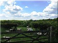
Sheep in the shade near Lakestreet Manor
On the centre horizon is the former Mayfield College, a Roman Catholic boys boarding which was finally closed in 1999. A clause in the developers contract meant they could not start work until the last school occupant had died or left. Mr Walters, a lay teacher, died six years later.
Image: © Dave Spicer
Taken: 25 May 2013
0.16 miles