IMAGES TAKEN NEAR TO
Criers Lane, MAYFIELD, TN20 6LG
Introduction
This page details the photographs taken nearby to Criers Lane, TN20 6LG by members of the Geograph project.
The Geograph project started in 2005 with the aim of publishing, organising and preserving representative images for every square kilometre of Great Britain, Ireland and the Isle of Man.

There are currently over 7.5m images from over14,400 individuals and you can help contribute to the project by visiting https://www.geograph.org.uk
Image Map (Loading...)


Getting Data...Please wait
Leaflet Map data © OpenStreetMap
Images are licensed for reuse under creativecommons.org/licenses/by-sa/2.0
Notes
- Clicking on the map will re-center to the selected point.
- The higher the marker number, the further away the image location is from the centre of the postcode.
Image Listing (38 Images Found)
Images are licensed for reuse under creativecommons.org/licenses/by-sa/2.0
Image
Details
Distance
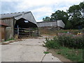
6
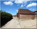
Outbuildings, Broadreed Farm
To the east of the farmhouse.
Image: © Simon Carey
Taken: 21 Aug 2023
0.05 miles
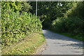
9
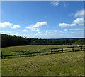
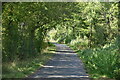
Forstall Hop Garden
The name of the field according to Mayfield's 1844 tithe map with Spratt Shaw to the left.
Image: © Simon Carey
Taken: 21 Aug 2023
0.06 miles
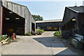
10
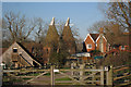
The Oasts, Broadreed Farm, Criers Lane, Five Ashes, East Sussex
Image: © Oast House Archive
Taken: 3 Jan 2009
0.06 miles