IMAGES TAKEN NEAR TO
West Street, MAYFIELD, TN20 6DT
Introduction
This page details the photographs taken nearby to West Street, TN20 6DT by members of the Geograph project.
The Geograph project started in 2005 with the aim of publishing, organising and preserving representative images for every square kilometre of Great Britain, Ireland and the Isle of Man.

There are currently over 7.5m images from over14,400 individuals and you can help contribute to the project by visiting https://www.geograph.org.uk
Image Map
Images are licensed for reuse under creativecommons.org/licenses/by-sa/2.0
Notes
- Clicking on the map will re-center to the selected point.
- The higher the marker number, the further away the image location is from the centre of the postcode.
Image Listing (38 Images Found)
Images are licensed for reuse under creativecommons.org/licenses/by-sa/2.0
Image
Details
Distance
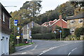
3

Field near Cranesden
Looking back towards Mayfield, the houses in the distance are on West Street near to the junction with Stone Cross.
Image: © Simon Carey
Taken: 23 May 2009
0.11 miles
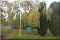
9

Ferns and ivy on wall
A wall of the old gas works in Love Lane
Image: © Patrick Roper
Taken: 30 May 2004
0.14 miles
10
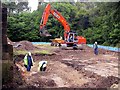
Groundworks in Love Lane
Site of the former gas works on the eastern side of Love Lane in a small disused quarry being prepared for housing development. The low blue fence around the level area is reptile exclusion fencing to stop slow-worms and other protected reptiles moving back into harm's way.
Image: © Patrick Roper
Taken: 6 Jun 2004
0.14 miles